Sudbury Reservoir
1898 establishments in MassachusettsFramingham, MassachusettsInfrastructure completed in 1898Lakes of Middlesex County, MassachusettsLakes of Worcester County, Massachusetts ... and 6 more
Marlborough, MassachusettsParks in Middlesex County, MassachusettsParks in Worcester County, MassachusettsReservoirs in MassachusettsSouthborough, MassachusettsWestborough, Massachusetts

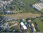
The Sudbury Reservoir (2.02 square miles) is an emergency backup Boston metropolitan water reservoir in Massachusetts, located predominantly in Southborough and Marlborough, with small sections in Westborough and Framingham. It was created when the Sudbury Dam was constructed to impound the Stony Brook branch of the Sudbury River; no part of the reservoir lies in the town of Sudbury. Nearly 5,000 acres (2,000 ha) in the Sudbury Reservoir watershed are administered by the Massachusetts Department of Conservation and Recreation as a limited-access public recreation area.
Excerpt from the Wikipedia article Sudbury Reservoir (License: CC BY-SA 3.0, Authors, Images).Sudbury Reservoir
Geographical coordinates (GPS) Address Nearby Places Show on map
Geographical coordinates (GPS)
| Latitude | Longitude |
|---|---|
| N 42.3225 ° | E -71.5125 ° |
Address
Sudbury Reservoir Watershed
01745
Massachusetts, United States
Open on Google Maps


