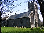
Sibton

Sibton is a village and civil parish on the A1120 road, in the East Suffolk district, in the English county of Suffolk. It is near the towns of Saxmundham and Halesworth, the village of Peasenhall and the hamlet of Sibton Green. The church is dedicated to St Peter; there is also the remains of a medieval abbey, Sibton Abbey. There is a large stately house set in the grounds of Sibton Park which dates back 1827 in the Georgian period, which is now used as a hotel. The estate consists of 4500 acres, being part of the Wilderness Reserve where there are holiday cottages and a lake. The Parish is also in close proximity to the River Yox which runs past the White Horse Inn and down through Pouy Street, it then goes on past both the A1120 road and a small, wooded area called Abbey Woods to pass through the grounds of Sibton Park and then on to Yoxford.
Excerpt from the Wikipedia article Sibton (License: CC BY-SA 3.0, Authors, Images).Sibton
Yoxford Road, East Suffolk
Geographical coordinates (GPS) Address Nearby Places Show on map
Geographical coordinates (GPS)
| Latitude | Longitude |
|---|---|
| N 52.273 ° | E 1.467 ° |
Address
Yoxford Road
Yoxford Road
IP17 2NB East Suffolk
England, United Kingdom
Open on Google Maps


