place

Levington

Civil parishes in SuffolkEast Suffolk (district)Suffolk geography stubsVillages in Suffolk
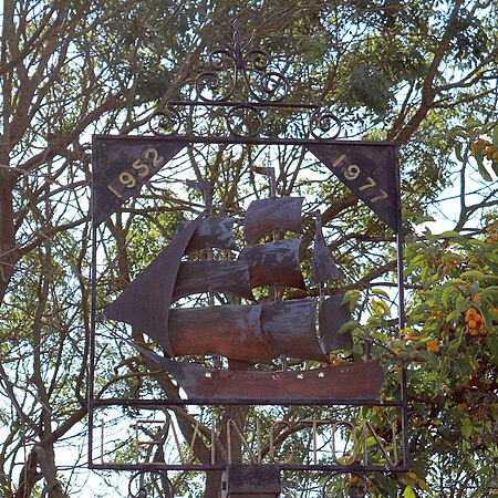
Levington village sign

Levington is a small village in the county of Suffolk, England in the East Suffolk district. The population of the parish including Stratton Hall at the 2011 Census was 259.

Excerpt from the Wikipedia article Levington (License: CC BY-SA 3.0, Authors, Images).

Levington
Church Lane, East Suffolk

Geographical coordinates (GPS) Address Nearby Places
placeShow on map

Wikipedia: LevingtonContinue reading on Wikipedia

Geographical coordinates (GPS)

Latitude Longitude
N 52 ° E 1.25 °
placeShow on map

Address

Church Lane

Church Lane
IP10 0LQ East Suffolk
England, United Kingdom
mapOpen on Google Maps

Levington village sign
Share experience

Nearby Places

Shotley
Shotley

Shotley is a village and civil parish 8 miles (13 km) south-east of Ipswich in the English county of Suffolk. It is in the Babergh district and gives its name to the Shotley peninsula between the Rivers Stour and Orwell. The parish includes the village of Shotley and the settlements of Shotley Gate and Church End. In 2011 civil parish had a population of 2,342. The village of Shotley is about a mile northwest from the tip of the peninsula, and lies either side of the B1456 road (the Street). In 2018 it had an estimated population of 854. There are two entries for Shotley (Scoteleia) and an adjacent settlement of Kirkton (Cherchetuna) listed in the Domesday Book of 1086.A school is located outside the village (half of 1 km east) opposite the turning into Oldhall Road. Oldhall Road is located east of the village leading north to St Mary's Church. The church is adjacent to a large naval cemetery cared for by the Commonwealth War Graves Commission. It has graves from both World Wars, not only those of HMS Ganges trainees, but also of Harwich-based warships killed in action with the Germans. There is a memorial to the dead from the 14-18 Harwich submarines.Shotley Hall is located near to the church. Rose Farm lies to the south of the village. The Shotley Parish Council holds its main meeting at the village hall at 19.15 hours every third Thursday of every month (except August), and meetings are open to the public. Shotley Gate is a settlement to the south of the village of Shotley at the tip of the peninsula. Shotley Gate also harbours HMS Ganges, a former Royal Navy training establishment (RNTE Shotley) for boys.

Foxhall, Suffolk
Foxhall, Suffolk

Foxhall is a civil parish in the East Suffolk district of Suffolk, England a few miles east of Ipswich. It is adjacent to the parishes of Kesgrave to the north, Martlesham to the northeast, Brightwell to the east, Purdis Farm to the south and the borough of Ipswich to the west. The three parishes of Brightwell, Foxhall and Purdis Farm have a common council. The 2001 population was 151 persons in 57 households according to the census, the population having increased at the 2011 Census to 200.Foxhall was recorded in the Domesday Book as "Foxehola". The history and meaning ('fox-hole') of the name Foxhall and many other place-names in the parish are studied in a paper by Briggs. The survey mentions 1 holding under Foxhall: 15 acres valued at 2 shillings held by the Abbot of Ely. Under the heading of "Derneford", "which is no doubt Darnford in Foxhall, there was 80 acres and 2 acres of meadow, 3 bordars in Saxon times having 4 ploughteams when it was valued at 40 shillings, but at the time of the survey 3 ploughteams only, when it was valued at 15 shillings." On the heath are several springs which give rise to the Mill River, a tributary of the River Deben. All Saints Church stood north of Mill River; it was in ruins by the mid-16th century. Much of this church building survives; the north wall is mainly intact and can still be seen put to a new use as part of the barn of Foxhall Farm. It stands at the top of a slope overlooking one of the backroads that link Foxhall Road with Bucklesham Road. Two enormous buttresses give the game away, as well as an expanse of flint amongst the red-brick. In 1530, Foxhall became an ecclesiastical hamlet to Brightwell. Despite its name the Foxhall Stadium, the home stadium of the Ipswich Witches speedway team, is actually just across the parish boundary in Kesgrave. The stadium is run by Spedeworth UK Ltd stock car promoters. More recently the banger racing Unlimited World Final has been staged here since its move from the Plough Lane venue in London. The World Final was first held at Foxhall in 2008 and proved to be a successful event. The World Final is predicted to stay at Foxhall due to the LEZ emission laws enforced in and around London making it difficult for many racers to transport their cars to the track. The stadium opened in the mid-1950s and has been in continuous operation since. Within the parish is the Nuffield Ipswich Hospital, a modern purpose-built hospital set in twenty acres of woodland. The village once had its own beer house (brewery with pub attached) called the Waddling Duck, long since demolished.There is a caravan site at Hollies Farm. Foxhall is commonly thought of as a village because of its history and because many relatively modern houses have been built along the part of Bucklesham Road that lies in the parish. However, it is just an area with a few houses bearing the name 'Foxhall'.