Zličín
Districts of PraguePrague geography stubs

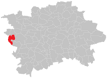
Zličín is a district and cadastral area in the west of Prague, located in an administrative district of the same name, which is part of Prague 5 in the old system and governs the cadastral areas Zličín, Sobín and the northern part of Třebonice. The name is best known among Praguers as the site for a large bus station, Metro terminus and depot and a number of shopping centres and hypermarkets, all of which are named after Zličín, despite belonging to the neighbouring district Třebonice.
Excerpt from the Wikipedia article Zličín (License: CC BY-SA 3.0, Authors, Images).Zličín
Nedašovská, Prague Zličín
Geographical coordinates (GPS) Address Nearby Places Show on map
Geographical coordinates (GPS)
| Latitude | Longitude |
|---|---|
| N 50.059444444444 ° | E 14.293333333333 ° |
Address
Nedašovská
155 21 Prague, Zličín
Prague, Czechia
Open on Google Maps


