place

Langloan railway station

1866 establishments in Scotland1964 disestablishments in ScotlandBeeching closures in ScotlandCoatbridgeDisused railway stations in North Lanarkshire
Former Caledonian Railway stationsPages with no open date in Infobox stationRailway stations in Great Britain closed in 1964Railway stations in Great Britain opened in 1866Use British English from August 2020
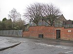
Langloan railway station (site), Lanarkshire (geograph 4060770)

Langloan railway station served the suburb of Langloan, North Lanarkshire, Scotland from 1866 from 1964 on the Rutherglen and Coatbridge Railway.

Excerpt from the Wikipedia article Langloan railway station (License: CC BY-SA 3.0, Authors, Images).

Langloan railway station
Annerley Place,

Geographical coordinates (GPS) Address Nearby Places
placeShow on map

Wikipedia: Langloan railway stationContinue reading on Wikipedia

Geographical coordinates (GPS)

Latitude Longitude
N 55.8538 ° E -4.0426 °
placeShow on map

Address

Annerley Place

Annerley Place
ML5 5LH , Langloan
Scotland, United Kingdom
mapOpen on Google Maps

Langloan railway station (site), Lanarkshire (geograph 4060770)
Share experience

Nearby Places

Drumpellier Country Park

Drumpellier Country Park is a country park situated to the west of Coatbridge, North Lanarkshire, Scotland. The park was formerly a private estate. The land was given over to the Burgh of Coatbridge for use as a public park in 1919, and was designated as a country park in 1984 by the then Monklands council, part of Strathclyde. The park covers an area of 500 acres (2.0 km2) and comprises two natural lochs (one of which is a Site of Special Scientific Interest (SSSI)), lowland heath, mixed woodlands and open grassland. The Monkland Canal lies towards the southern perimeter of the park. The lochs and the canal attract many water birds, both resident (such as swans and mallard ducks) and over-wintering migrants, and the loch shores and woodland floor provides an abundance of wild flora. The woodlands are also rich in bird life, small wild animals and many types of fungi.The lochs at Drumpellier are part of a chain of kettle ponds formed towards the end of the last ice age. As the glacier that covered most of Scotland slipped down towards the sea it churned up great tracts of land. This created the great lochs, such as Lomond and Linnhe, and also produced small pockets of water such as the Garnkirk chain of Hogganfield, Frankfield and the Bishops Lochs (an SSI that comes under Glasgow City Councils administration) that include Drumpellier's Lochs, Woodend and Lochend. The loch side path is approximately 1 mile (1.6 km) long and it is suitable for bikes. Since July 2019 the park has been the location of Drumpellier Country Parkrun.

Coatbridge
Coatbridge

Coatbridge (Scots: Cotbrig or Coatbrig, Scottish Gaelic: Drochaid a' Chòta) is a town in North Lanarkshire, Scotland, about 8.5 miles (13.5 km) east of Glasgow city centre, set in the central Lowlands. While the earliest known settlement of the area dates back to the Stone Age era, the founding of the town can be traced to the 12th century, when a Royal Charter was granted to the monks of Newbattle Abbey by King Malcolm IV. Along with neighbouring town Airdrie, Coatbridge forms the area known as the Monklands (population approximately 90,000 including outlying settlements), often considered to be part of the Greater Glasgow urban area – although officially they have not been included in population figures since 2016 due to small gaps between the Monklands and Glasgow built-up areas. In the last years of the 18th century, the area developed from a loose collection of hamlets into the town of Coatbridge. The town's development and growth have been intimately connected with the technological advances of the Industrial Revolution, and in particular with the hot blast process. Coatbridge was a major Scottish centre for iron works and coal mining during the 19th century and was then described as 'the industrial heartland of Scotland' and the 'Iron Burgh'. Coatbridge also had a notorious reputation for air pollution and the worst excesses of industry. However, by the 1920s, coal seams were exhausted and the iron industry in Coatbridge was in rapid decline. After the Great Depression, the Gartsherrie ironwork was the last remaining iron works in the town. One publication has commented that in modern-day Coatbridge 'coal, iron and steel have all been consigned to the heritage scrap heap'.