Upper Charles River Reservation
Charles RiverMassachusetts natural resourcesParks in BostonParks in Dedham, MassachusettsParks in Middlesex County, Massachusetts ... and 4 more
Parks in Norfolk County, MassachusettsParks in Suffolk County, MassachusettsState parks of MassachusettsUse mdy dates from August 2023

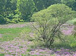
The Upper Charles River Reservation is a Massachusetts state park encompassing portions of the banks of the Charles River between the Watertown Dam in Watertown and Riverdale Park in Dedham and the West Roxbury neighborhood of Boston. The park is managed by the Massachusetts Department of Conservation and Recreation. It includes land in the communities of Watertown, Waltham, Newton, Weston, Wellesley, Needham, Dedham, and Boston. Some of the Charles River Reservation Parkways also fall within the park boundaries. The Charles River Bike Path follows the river through much of the reservation.
Excerpt from the Wikipedia article Upper Charles River Reservation (License: CC BY-SA 3.0, Authors, Images).Upper Charles River Reservation
Blue Heron Trail,
Geographical coordinates (GPS) Address Nearby Places Show on map
Geographical coordinates (GPS)
| Latitude | Longitude |
|---|---|
| N 42.272222222222 ° | E -71.174444444444 ° |
Address
Blue Heron Trail
Blue Heron Trail
02132
Massachusetts, United States
Open on Google Maps


