place

Bloomvale Historic District

Cotton mills in the United StatesHistoric districts in Dutchess County, New YorkHistoric districts on the National Register of Historic Places in New York (state)Industrial buildings and structures on the National Register of Historic Places in New York (state)NRHP infobox with nocat
National Register of Historic Places in Dutchess County, New YorkSawmills in the United StatesTypes of drinking establishmentUse mdy dates from August 2023
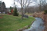
East Branch Wappingers Creek at Bloomvale, NY

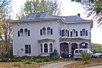
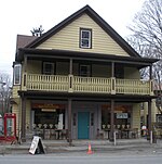
The Bloomvale Historic District is located east of the hamlet of Salt Point, New York, United States. It is a collection of buildings and structures around the intersection of Clinton Corners Road (Dutchess County Route 13), state highway NY 82 and the East Branch of Wappinger Creek. Most of it is in the Town of Pleasant Valley; the eastern portion is in the Town of Washington. The village (and thus the district) was named after Isaac Bloom, a landowner and politician in the area during and after the Revolutionary War who built a Federal style mansion and operated the first mill on the creek (and thus sometimes historically known as Bloom's Mill or Bloomdale). By the mid-19th century it had grown into a small industrial town around what was now a cotton mill. After a fire destroyed the mill, the community faded away in the early 20th century. A later owner was able to use the remaining facilities as a cider mill until almost the middle of the century. In 1991 the dam, the remaining mill buildings, and some of the houses were grouped into a historic district and listed on the National Register of Historic Places.

Excerpt from the Wikipedia article Bloomvale Historic District (License: CC BY-SA 3.0, Authors, Images).

Bloomvale Historic District
State Highway 82, Town of Washington

Geographical coordinates (GPS) Address Nearby Places
placeShow on map

Wikipedia: Bloomvale Historic DistrictContinue reading on Wikipedia

Geographical coordinates (GPS)

Latitude Longitude
N 41.800277777778 ° E -73.7575 °
placeShow on map

Address

State Highway 82 4916
12578 Town of Washington
New York, United States
mapOpen on Google Maps

East Branch Wappingers Creek at Bloomvale, NY
Share experience

Nearby Places

Creek Meeting House and Friends' Cemetery

Creek Meeting House and Friends' Cemetery is a historic Society of Friends meeting house and cemetery on Salt Point Turnpike/Main Street in Clinton Corners, Dutchess County, New York, United States. It was built between 1777 and 1782. The meeting house is a two-story, squarish building constructed of fieldstone. Land for the building was given by Able Peters, whose substantial brick house is the next building on the same side of the road north of the meeting house. In 1828 the Friends Creek Meeting split into Hicksite and Orthodox meetings. The Orthodox meeting moved about a mile north of Clinton Corners to the Shingle Meeting House located on the grounds of the current Friends Upton Lake Cemetery. The Creek Meeting sold the building to the Upton Lake Grange in 1927 and joined the Bulls Head Meeting in 1936.The Grange transferred the building to the Town of Clinton Historical Society in 1995. The original slate covered, moderately pitched gable roof was replaced with metal in the early 21st century by the Historical Society.The still active surrounding cemetery contains over 100 headstones of slate in a plain Quaker style along with many marble and newer granite. The early tradition of marking graves with wood has also left nearly 100 unmarked graves which are noted on the July 1938 survey of the cemetery. The Peters family plot in the northwestern portion of the burial grounds was moved to make room for the Poughkeepsie and Eastern Railroad and is distinguished by its low enclosure.The Creek Meeting house was listed on the National Register of Historic Places in 1989 and is located directly across the street from the Clinton Corners Friends Church.

Clinton Corners Friends Church

Clinton Corners Friends Church is a historic Society of Friends meeting house on Salt Point Turnpike/Main Street in Clinton Corners, Dutchess County, New York, United States. It is located directly across the street from the Creek Meeting House and Friends' Cemetery. The congregation originated during the Quaker schism of 1828 when Creek Friends Meeting split into Hicksite and Orthodox meetings. The Orthodox meeting moved about a mile north of Clinton Corners to the Shingle Meeting House located on the grounds of the current Friends Upton Lake Cemetery. The Orthodox meeting grew as they welcomed Protestants from other denominations and began to refer to themselves as a "church". In 1890 they moved back into the village to the current location and built a one-story, rectangular frame building on a stone foundation right across from the still active Creek Meeting. In 1916, feeling the need for more space, this building was moved further from the road and a shingle style rectangular structure with a jerkin-head gable roof was built and attached to front of relocated 1890 structure. The former 1890 meeting room was converted into a gym and dining hall for community suppers. A small addition in the 1920s at the back included a stage. The building was listed on the National Register of Historic Places in 1989. The Orthodox Meeting followed further schisms in the 19th century towards more mainstream Protestant practices and became a Friends Church, and part of Friends United Meeting. In the mid-1970s the congregation aligned with Evangelical Friends and started a school. By the mid-1980s the congregation had aligned with the Evangelical Free Church of America and the last services in the building were held in 1986. The building soon after became a private residence.