River Street Historic District (New Haven, Connecticut)
Fair Haven (New Haven)Historic districts in New Haven, ConnecticutHistoric districts on the National Register of Historic Places in ConnecticutNRHP infobox with nocatNational Register of Historic Places in New Haven, Connecticut ... and 1 more
Use mdy dates from August 2023

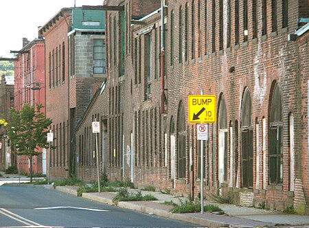
The River Street Historic District encompasses a historic industrial area in the Fair Haven section of New Haven, Connecticut. Located south of Chapel Street between James Street and Blatchley Avenue, the industrial buildings here date to New Haven's growth as a major industrial center between the American Civil War and World War I, with significant emphasis on metalworking businesses. The district was listed on the National Register of Historic Places in 1989.
Excerpt from the Wikipedia article River Street Historic District (New Haven, Connecticut) (License: CC BY-SA 3.0, Authors, Images).River Street Historic District (New Haven, Connecticut)
Lloyd Street, New Haven
Geographical coordinates (GPS) Address External links Nearby Places Show on map
Geographical coordinates (GPS)
| Latitude | Longitude |
|---|---|
| N 41.302222222222 ° | E -72.901111111111 ° |
Address
River Street Historic District
Lloyd Street
05610 New Haven
Connecticut, United States
Open on Google Maps


