place

St John the Evangelist, Penge

1866 establishments in England19th-century Church of England church buildingsChurch of England church buildings in the London Borough of BromleyChurches completed in 1866Diocese of Rochester
Grade II listed buildings in the London Borough of BromleyGrade II listed churches in LondonLondon church stubs
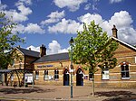
St John's Church, Penge (2017)

Saint John the Evangelist is the Church of England parish church of Penge, Kent (now the London Borough of Bromley), in the Diocese of Rochester, Greater London. It is located on Penge High Street, and was erected 1847 to designs of architects Edwin Nash & J. N. Round. Later in 1861, Nash alone added the gabled aisles, and in 1866 the transepts. The Pevsner Buildings of England series guides describe it as "Rock-faced ragstone. West tower and stone broach spire. Geometrical tracery, treated in Nash's quirky way. The best thing inside is the open timber roofs, those in the transepts especially evocative, eight beams from all four directions meeting in mid air. It has been Grade II listed since 1990.The church is prevented from dominating the skyline of Penge by the distant tower farther south on Beckhenham Road of the Fortress Romanesque-looking Congregational church, built 1912 to designs by P. Morley Horder with passage aisles and clerestory, and shafts on large, excellently carved corbels. The early funding of the church came from John Dudin Brown who was a Thames wharfinger.

Excerpt from the Wikipedia article St John the Evangelist, Penge (License: CC BY-SA 3.0, Authors, Images).

St John the Evangelist, Penge
Barson Close, London Penge (London Borough of Bromley)

Geographical coordinates (GPS) Address External links Nearby Places
placeShow on map

Wikipedia: St John the Evangelist, PengeContinue reading on Wikipedia

Geographical coordinates (GPS)

Latitude Longitude
N 51.4167 ° E -0.055 °
placeShow on map

Address

St John the Evangelist

Barson Close
SE20 7EQ London, Penge (London Borough of Bromley)
England, United Kingdom
mapOpen on Google Maps

linkWikiData (Q7588983)
linkOpenStreetMap (31181229)

St John's Church, Penge (2017)
Share experience

Nearby Places

Penge Common

Penge Common was an area of north east Surrey and north west Kent which now forms part of London, England; covering most of Penge, all of Anerley, and parts of surrounding suburbs including South Norwood. It abutted the Great North Wood and John Rocque's 1745 map of London and its environs showed that Penge Common now included part of that wood. An area named Penge Place was excised from the northernmost part of Penge Common and was later used for the relocation of The Crystal Palace. It included parts of the Great North Wood which later became Crystal Palace Park. The London and Croydon Canal was built across Penge Common along what is now the line of the railway through Penge West railway station, deviating to the south before Anerley railway station. There is a remnant at the northern corner of Betts Park, Anerley. Following the closure of the London and Croydon Canal, The London and Croydon Railway was built largely along the same course, opening in 1839. Isambard Kingdom Brunel built an atmospheric railway along this course. The Croydon Enclosure Act of 1797 and the Penge Enclosure Acts in 1805, 1806, and 1827 resulted in most of the remaining Common and Penge Green being subdivided. One of the first new houses was named "Annerley" which gave its name to the Anerley area; the name means lonely in Gaelic, which hardly applies to the area in the 21st century. Remnants of Penge Common that survive as public open spaces include Crystal Palace Park, Penge Recreation Ground and Betts Park in Anerley.