Ffos-y-ffin
Villages in CeredigionWales geography stubs
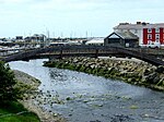
Ffos-y-ffin is a village near Aberaeron, Wales. It is a great place to see the Red Kites. It is on the very scenic road between Aberystwyth and Cardigan. There is a public house called the Red Lion. The name translates into English as "Boundary Ditch", the ditch in question can be seen from the bridge just before the public house. Ffos-y-ffin is on the A487. Travelling south west along A487 the next village is Llwyncelyn.
Excerpt from the Wikipedia article Ffos-y-ffin (License: CC BY-SA 3.0, Authors).Ffos-y-ffin
A487,
Geographical coordinates (GPS) Address Nearby Places Show on map
Geographical coordinates (GPS)
| Latitude | Longitude |
|---|---|
| N 52.2206 ° | E -4.2746 ° |
Address
A487
SA46 0HA , Henfynyw
Wales, United Kingdom
Open on Google Maps


