Kap Shui Mun
Channels of Hong KongHong Kong geography stubsLantau IslandMa WanNew Territories ... and 1 more
Use Hong Kong English from July 2017

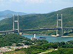
Kap Shui Mun (Chinese: 汲水門) or Throat Gates (historically spelled Capsuimoon) is the channel between Lantau Island and Ma Wan in Hong Kong. It is part of major sea route along the coast of South China, from Victoria Harbour to the Pearl River. It joins north with Urmston Road. Kap Shui Mun Bridge, part of Route 8, spans the channel.
Excerpt from the Wikipedia article Kap Shui Mun (License: CC BY-SA 3.0, Authors, Images).Kap Shui Mun
Lantau Link,
Geographical coordinates (GPS) Address Nearby Places Show on map
 Continue reading on Wikipedia
 Geographical coordinates (GPS)
| Latitude | Longitude |
|---|---|
| N 22.343055555556 ° | E 114.05638888889 ° |
Address
汲水門大橋 Kap Shui Mun Bridge
Lantau Link
Hong Kong, China
Open on Google Maps