Shark Island (Port Jackson)

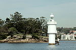
Shark Island is an island located within Sydney Harbour, in New South Wales, Australia. The island is 1.5 hectares (3.7 acres) in area, measuring some 250 metres by 100 metres, and lies off the Sydney suburbs of Point Piper, Rose Bay and Vaucluse, in the eastern section of the harbour between the Harbour Bridge and the harbour entrance. The island was known by the local Aboriginal people as Boambilly, and the current name comes from its shape, which is claimed to resemble a shark. Shark Island Light is an active pile lighthouse located just north of Shark Island, an island in Sydney Harbour, New South Wales, Australia. Its light is only visible on in the fairway of the harbour, between Shark Point and Point Piper.
Excerpt from the Wikipedia article Shark Island (Port Jackson) (License: CC BY-SA 3.0, Authors, Images).Shark Island (Port Jackson)
Wunulla Road, Sydney Point Piper
Geographical coordinates (GPS) Address Nearby Places Show on map
Geographical coordinates (GPS)
| Latitude | Longitude |
|---|---|
| N -33.858355555556 ° | E 151.25763888889 ° |
Address
Wunulla Road
2027 Sydney, Point Piper
New South Wales, Australia
Open on Google Maps


