Val Camonica

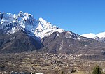
Val Camonica or Valcamonica (Eastern Lombard: Al Camònega), also Valle Camonica and anglicized as Camonica Valley, is one of the largest valleys of the central Alps, in eastern Lombardy, Italy. It extends about 90 kilometres (56 mi) from the Tonale Pass to Corna Trentapassi, in the commune of Pisogne near Lake Iseo. It has an area of about 1,335 km2 (515 sq mi) and 118,323 inhabitants. The River Oglio runs through its full length, rising at Ponte di Legno and flowing into Lake Iseo between Pisogne and Costa Volpino. Almost all of the valley is included in the administrative territory of the province of Brescia, except for Lovere, Rogno, Costa Volpino and the Val di Scalve, which belong to the province of Bergamo. Since 1979, the rock drawings located along the valley are a UNESCO World Heritage Site, while the entire valley became a UNESCO World Biosphere Reserve in 2018.
Excerpt from the Wikipedia article Val Camonica (License: CC BY-SA 3.0, Authors, Images).Val Camonica
SS42, Comunità montana della valle Camonica
Geographical coordinates (GPS) Address Nearby Places Show on map
Geographical coordinates (GPS)
| Latitude | Longitude |
|---|---|
| N 46.0075 ° | E 10.3475 ° |
Address
SS42
25044 Comunità montana della valle Camonica
Lombardy, Italy
Open on Google Maps


