place

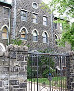
Monastery and Church of Saint Michael the Archangel

1875 establishments in New Jersey19th-century Roman Catholic church buildings in the United StatesChristian monasteries in the United StatesChurches in Hudson County, New JerseyChurches on the National Register of Historic Places in New Jersey
Historic districts in Hudson County, New JerseyItalianate architecture in New JerseyItalianate church buildings in the United StatesKorean-American culture in New JerseyKorean churches in the United StatesNational Register of Historic Places in Hudson County, New JerseyNew Jersey Register of Historic PlacesPresbyterian Church in America churches in New JerseyRenaissance Revival architecture in New JerseyRoman Catholic churches completed in 1875Second Empire architecture in New JerseyUnion City, New Jersey
8.14.09StMichaelsMonasteryByLuigiNovi

The Monastery and Church of Saint Michael the Archangel, known locally as Saint Michael's Monastery Church, is a state and national historic place in Union City, New Jersey, United States. Formally opened in 1869 and completed in 1875, the grounds of the complex are bounded West Street and Summit Avenue between 18th and 21st Streets. The small street leading to its front entrance from the east is called Monastery Place. At one time the largest Roman Catholic church in Hudson County, it has since become home to a Presbyterian congregation while part of the grounds are used for housing and education. At one time its walls were adorned by artwork by Hildreth Meière, until rain damage prompted their removal from public view.

Excerpt from the Wikipedia article Monastery and Church of Saint Michael the Archangel (License: CC BY-SA 3.0, Authors, Images).

Monastery and Church of Saint Michael the Archangel
Saint Michaels Walk,

Geographical coordinates (GPS) Address Nearby Places
placeShow on map

Wikipedia: Monastery and Church of Saint Michael the ArchangelContinue reading on Wikipedia

Geographical coordinates (GPS)

Latitude Longitude
N 40.765555555556 ° E -74.037222222222 °
placeShow on map

Address

Hudson Korean Presbyterian Church Parking Lot

Saint Michaels Walk
07087
New Jersey, United States
mapOpen on Google Maps

8.14.09StMichaelsMonasteryByLuigiNovi
Share experience

Nearby Places

Union City High School (New Jersey)

Union City High School is a four-year comprehensive public high school serving students in ninth through twelfth grades from Union City, in Hudson County, in the U.S. state of New Jersey, operating as part of the Union City Board of Education. The four-story school is located between Kennedy Boulevard and Summit Avenue, from 24th to 26th Street, with additional facilities a block south on Kerrigan Avenue. The school has been accredited by the Middle States Association of Colleges and Schools Commission on Elementary and Secondary Schools through July 2023.As of the 2021–22 school year, the school had an enrollment of 2,958 students and 181.0 classroom teachers (on an FTE basis), for a student–teacher ratio of 16.3:1. There were 2,108 students (71.3% of enrollment) eligible for free lunch and 281 (9.5% of students) eligible for reduced-cost lunch. Based on 2021-22 data from the New Jersey Department of Education, it was the second-largest high school in the state (behind Passaic County Technical Institute) and one of 29 schools with more than 2,000 students.The school administratively formed in 2008, with athletic teams combined, but for the first year the students were still at their former buildings. Its current building opened in September 2009, at that time merging the student bodies of the city's prior two high schools, Union Hill High School and Emerson High School, and marking the first high school opened in the city in 90 years. The school, which was built on the site of the former Roosevelt Stadium, cost $180 million, covers 4.5 acres (1.8 ha) and includes a rooftop football field. The school's colors are navy blue and silver.

Union City, New Jersey

Union City is a city in the northern part of Hudson County, in the U.S. state of New Jersey. As of the 2020 United States census, the city was the state's 18th-most-populous municipality, with a population of 68,589, an increase of 2,134 (+3.2%) from the 2010 census count of 66,455, which in turn had reflected a decline of 633 (−0.9%) from the 67,088 counted in the 2000 census. As of the 2010 Census, among cities with a population of more than 50,000, it was the most densely populated city in the United States, with a density of 54,138 per square mile of land. The Census Bureau's Population Estimates Program calculated that the city's population was 65,366 in 2022, ranking the city the 590th-most-populous in the country.Union City was incorporated as a city by an act of the New Jersey Legislature on June 1, 1925, with the merger of Union Hill and West Hoboken Township.Two major waves of immigration, first of German speakers and then of Spanish speakers, greatly influenced the development and character of Union City. Its two nicknames, "Embroidery Capital of the United States" and "Havana on the Hudson", reflect important aspects of that history. Thousands visit Union City each year to see the nation's longest-running passion play.Union City is where Mallomars were first sold and the site of the first lunch wagon, built by Jerry and Daniel O'Mahoney and John Hanf, which helped spark New Jersey's golden age of diner manufacturing, for which the state is colloquially referred to by author Richard J.S. Gutman as the "diner capital of the world".

Transfer Station (Hudson County)

Transfer Station is the name of a section of Hudson County, New Jersey, which radiates from the intersection where Paterson Plank Road crosses Summit Avenue at 7th Street. It is near the tripoint where the borders of Jersey City Heights, North Bergen, and Union City intersect, which is a few blocks to the southwest of the station, at the intersection of Secaucus Road and Kennedy Boulevard.The section lies west of Washington Park, a Hudson county park, along the shared city line of Jersey City and Union City running diagonal across the urban grid. It lies just to the northeast of Chelsea in Jersey City. Here Kennedy Boulevard curves eastward following the contour of the Hudson Palisades. Secaucus Road, which creates part of the city line, begins in the district, and descends the Western Slope where North Bergen begins.The area takes its name from the fact that it was once a transfer point for buses three trolley lines. The neighborhood was also the site, in 1912, of the first lunch wagon built by Jerry and Daniel O'Mahoney and John Hanf, which was bought for $800 and operated by restaurant entrepreneur Michael Griffin, who chose the location for its copious foot traffic. The wagon helped spark New Jersey's golden age of diner manufacturing, which in turn made the state the diner capital of the world. In the decades that followed, nearly all major U.S. diner manufacturers, including Jerry O'Mahoney Inc., started in New Jersey. During World War II, the area was a 24-hour hotspot for U.S. servicemen, who patronized the dozens of nightclubs located there.