place

Bishop Wilton

Civil parishes in the East Riding of YorkshireOpenDomesdayUse British English from October 2014Villages in the East Riding of Yorkshire
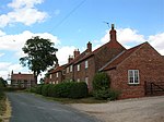
Cottages and Church Bishop Wilton geograph.org.uk 1429472

Bishop Wilton is a small village and civil parish in the East Riding of Yorkshire, England. It is situated approximately 4 miles (6 km) north of Pocklington and 6 miles (10 km) east of Stamford Bridge. The civil parish is formed by the village of Bishop Wilton and the hamlets of Gowthorpe and Youlthorpe. According to the 2011 UK census, Bishop Wilton parish had a population of 554 in 227 households, an increase on the 2001 UK census figure of 500 in 199 households. Just north of the village lies Bishop Wilton Wold, more commonly referred to as Garrowby Hill. At 807 feet (246 m) above sea level, it is the highest point on the Yorkshire Wolds. Through the centre of Bishop Wilton runs a shallow beck, flanked on both sides by open grass verges. The village has a local shop, a small primary school, an art gallery with screen printing workshop, and the Fleece Inn public house. St Edith's, the medieval Church of England parish church, is dedicated to Edith of Wilton. The church was restored in 1858–59 with internal embellishment to designs by J. L. Pearson. It was designated a Grade I listed building in January 1967 and is now recorded in the National Heritage List for England, maintained by Historic England. The church is on the Sykes Churches Trail devised by the East Yorkshire Churches Group. Around the village there are walks on the Wolds with views across the Vale of York.

Excerpt from the Wikipedia article Bishop Wilton (License: CC BY-SA 3.0, Authors, Images).

Bishop Wilton
Main Street,

Geographical coordinates (GPS) Address Nearby Places
placeShow on map

Wikipedia: Bishop WiltonContinue reading on Wikipedia

Geographical coordinates (GPS)

Latitude Longitude
N 53.985858 ° E -0.785959 °
placeShow on map

Address

Main Street

Main Street
YO42 1RX , Bishop Wilton
England, United Kingdom
mapOpen on Google Maps

Cottages and Church Bishop Wilton geograph.org.uk 1429472
Share experience

Nearby Places

Yapham
Yapham

Yapham is a village and civil parish in the East Riding of Yorkshire, Northern England. It is situated about 2 miles (3.2 km) north-east of Pocklington. The parish includes the hamlet of Meltonby and is approximately 1,830 acres (740 ha).The village was originally known as Iapun / Lapun and the first reference of the village can be found in the Domesday Book (1086). The village was later known as Yapome with further references in Ancient Petitions, Henry III – James I (1390) when William Lokton petitioned the King for the restoration of the manor of Bolton and other property in Yapome (Yapham). It is not known when the current spelling of the name was adopted. The village Church, St Martin's, is a small church was partially rebuilt in 1777–8. It consists of chancel and nave, with a western turret, containing one bell. The church was designated a Grade II* listed building in 1967 and is now recorded in the National Heritage List for England, maintained by Historic England. The Wesleyans built a chapel in 1865 however this has been converted into a private house in the 1980s. A school has served the village and surrounding area since before 1773 with a new school built in 1875 to accommodate up to 45 children. The school closed in 1972 with the remaining children transferring to St Martin's Church of England Voluntary Aided Primary School in Fangfoss. The old school buildings are now used as a village hall. Yapham was served by Yapham Gate railway station on the York–Beverley line for a short while between 1855 and 1865. The population of Yapham has remained reasonably unchanged for many years with the 1891 UK census identifying a population of 191 with the 2001 UK census identifying a population of 175. Since 2001, however there have been a number of new houses built in the village. The population of the civil parish at the 2011 Census was shown as 217. Although the civil parish is called "Yapham" its parish council is called "Yapham cum Meltonby Parish Council".Yapham was formerly a township and chapelry in the parish of Pocklington, in 1866 it became a civil parish as Yapham cum Meltonby, on 1 April 1935 the parish was renamed to "Yapham".Yapham Cricket Club has been playing at the Cricket Ground on the edge of the village for almost 100 years and is one of only a few clubs to play on through the war. The club now has a strong junior section as well as both Men's and Ladies Senior Teams. The Gravel Pit Allotment Association was formed in 2009 to convert the old gravel pit field in between Yapham and Meltonby into community allotments.

Fangfoss
Fangfoss

Fangfoss is a village and civil parish in the East Riding of Yorkshire, England. It is situated approximately 11 miles (18 km) to the east of the city of York and 3.5 miles (6 km) north-west of the town of Pocklington. The parish includes Bolton. The civil parish is called "Fangfoss" and its parish council is called "Fangfoss with Bolton Parish Council" after Bolton parish was abolished on 1 April 1935 and merged with Fangfoss. The parish covers an area of 900.98 hectares (2,226.4 acres). In 2011 it had a population of 581, a decrease on the 2001 UK census figure of 602.In 1823 Fangfoss was listed as the parish of 'Fangfoss-with-Spittle'. The village was in the Wapentake of Harthill. Population was 154, with occupations including twelve farmers, a shopkeeper, a shoemaker, and a schoolmaster. The landlord of The Carpenter's public house was also a village carpenter. The village chapel was in the charge of the vicar of Barnby-upon-the-Moor, and under the patronage of the Dean of York. The parish church of St Martin was designated a Grade II* listed building in January 1967 and is now recorded in the National Heritage List for England, maintained by Historic England.Fangfoss Hall was designated a Grade II* listed building in 1967 and is now recorded in the National Heritage List for England, maintained by Historic England. Fangfoss was served by Fangfoss railway station on the York to Beverley Line between 1847 and 1959. In 1987 the station was given a Grade II listed building status.In addition to the parish church, Fangfoss has a primary school and pub called The Carpenters Arms. A village park was created in 2002 to mark the Queen's Golden Jubilee and is called Jubilee Park.Fangfoss hosts an annual arts festival called Fangfest.