Minneapolis–Saint Paul

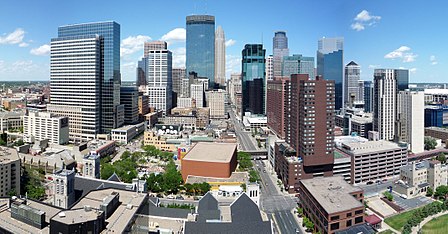
Minneapolis–Saint Paul is a metropolitan area centered around the confluence of the Mississippi, Minnesota and St. Croix rivers in the U.S. state of Minnesota. It is commonly known as the Twin Cities after the area's two largest cities, Minneapolis and Saint Paul. Minnesotans often refer to the two together (or the seven-county metro area collectively) simply as "the cities". It is Minnesota’s economic, cultural, and political center. Minneapolis and Saint Paul are independent municipalities with defined borders. Minneapolis sits mostly on the west side of the Mississippi River on lake-covered terrain. Although most of the city is residential neighborhoods, it has a business-dominated downtown area with some historic industrial areas, the Mill District and the Warehouse District. Minneapolis also has a popular uptown area. Saint Paul, which sits mostly on the east side of the river, has quaint tree-lined neighborhoods, a vast collection of well-preserved late-Victorian architecture, and a number of colleges. Both cities and the surrounding areas are known for their woods, lakes, hills and creeks.Originally inhabited by the Ojibwe and Dakota people, the cities were settled by various Europeans. Minneapolis was strongly influenced by early Scandinavian and Lutheran settlers, while Saint Paul was settled predominantly by the French, the Irish, and German Catholics. Today, both urban areas are home to new immigrant communities, including Somalis, Hmong, Oromo, Cameroonians, and Liberians. "Twin Cities" is sometimes used to refer to the seven-county region governed by the Metropolitan Council regional governmental agency and planning organization. The United States Office of Management and Budget officially designates 15 counties as the "Minneapolis–St. Paul–Bloomington MN–WI Metropolitan Statistical Area". It is the 16th-largest metropolitan statistical area and third-largest metropolitan area in the Midwest, with a population of 3,690,261 at the 2020 census. The larger 21-county Minneapolis–St. Paul MN–WI Combined Statistical Area, which also ranks as the 16th-largest, had a population of 4,078,788 at the 2020 census.
Excerpt from the Wikipedia article Minneapolis–Saint Paul (License: CC BY-SA 3.0, Authors, Images).Minneapolis–Saint Paul
East River Road, Saint Paul Union Park
Geographical coordinates (GPS) Address Nearby Places Show on map
Geographical coordinates (GPS)
| Latitude | Longitude |
|---|---|
| N 44.95 ° | E -93.2 ° |
Address
East River Road 303
55104 Saint Paul, Union Park
Minnesota, United States
Open on Google Maps


