place

Waterbury, Connecticut

1677 establishments in ConnecticutAlbanian-American historyCities in ConnecticutCities in Naugatuck Valley Planning Region, ConnecticutCities in New Haven County, Connecticut
Cities in the New York metropolitan areaGreater Waterbury, ConnecticutHispanic and Latino American culture in ConnecticutItalian-American culture in ConnecticutLittle Italys in the United StatesPages with non-numeric formatnum argumentsPopulated places established in 1674Populated places established in 1677Use mdy dates from October 2016Waterbury, Connecticut
Western approach to Waterbury CT

Waterbury is a city in the U.S. state of Connecticut on the Naugatuck River, 33 miles (53 km) southwest of Hartford and 77 miles (124 km) northeast of New York City. Waterbury is the largest city in the Naugatuck Valley Planning Region and second-largest city in New Haven County. According to the 2020 US Census, in 2020 Waterbury had a population of 114,403. As of the 2010 census, Waterbury had a population of 110,366, making it the 9th largest city in New England and the 5th largest city in Connecticut.Throughout the first half of the 20th century, Waterbury had large industrial interests and was the leading center in the United States for the manufacture of brassware (including castings and finishings), as reflected in the nickname the "Brass City" and the city's motto Quid Aere Perennius? ("What Is More Lasting Than Brass?"). It was also noted for the manufacture of watches and clocks (Timex). The city is alongside Interstate 84 (Yankee Expressway) and Route 8 and has a Metro-North railroad station with connections to Grand Central Terminal. Waterbury is also home to Post University and the regional campuses of the University of Connecticut, University of Bridgeport, Western Connecticut State University as well as Naugatuck Valley Community College.

Excerpt from the Wikipedia article Waterbury, Connecticut (License: CC BY-SA 3.0, Authors, Images).

Waterbury, Connecticut
West Main Street, Waterbury

Geographical coordinates (GPS) Address Nearby Places
placeShow on map

Wikipedia: Waterbury, ConnecticutContinue reading on Wikipedia

Geographical coordinates (GPS)

Latitude Longitude
N 41.556111111111 ° E -73.041388888889 °
placeShow on map

Address

West Main Street 21
06702 Waterbury
United States
mapOpen on Google Maps

Western approach to Waterbury CT
Share experience

Nearby Places

Downtown Waterbury Historic District

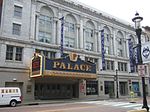
The Downtown Waterbury Historic District is the core of the city of Waterbury, Connecticut, United States. It is a roughly rectangular area centered on West Main Street and Waterbury Green, the remnant of the original town commons, which has been called "one of the most attractive downtown parks in New England."The Green was the city's first center, with the buildings around it representing all types of uses, from residences to churches to public buildings. Many early buildings were cleared as the city grew and industrialized. Nearby Exchange Place, the junction of the city's streetcar lines, later emerged as a center for retailing. A devastating 1902 fire in that area led to more clearing and rebuilding. In its wake the city's government buildings were moved to a new municipal complex on Grand Street designed by Cass Gilbert, in accordance with the principles of the City Beautiful movement. Most of its buildings, large commercial blocks, date to the peak years of the city's industrial prosperity, the late 19th and early 20th centuries. A few earlier buildings survived a devastating 1902 fire. Among them works by locally and nationally prominent architects, the latter group including Henry Bacon and Henry Dudley in addition to Gilbert. They include a variety of contemporary architectural styles, particularly the Second Renaissance Revival, Georgian Revival and Romanesque Revival modes. In 1983 the area was recognized as a historic district and listed on the National Register of Historic Places. At that time, there were three listings on the Register within the district, including the municipal complex and a pair of houses listed together. Another old hotel has since been listed as well as a contributing property.

Waterbury Municipal Center Complex

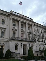
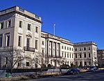
The Waterbury Municipal Center Complex, also known as the Cass Gilbert National Register District, is a group of five buildings, including City Hall, on Field and Grand streets in Waterbury, Connecticut, United States. They are large stone and brick structures, all designed by Cass Gilbert in the Georgian Revival and Second Renaissance Revival architectural styles, built during the 1910s. In 1978 they were designated as a historic district and listed on the National Register of Historic Places. They are now contributing properties to the Downtown Waterbury Historic District. The complex was financed by the Chase family, owners of the Chase Brass Company, one of Waterbury's major industries at the time. In the wake of a 1902 fire that had destroyed a portion of downtown, the Chases and other local businessmen saw an opportunity for urban renewal. Cass Gilbert won the competition to design a new complex a few blocks from the old city hall building (since demolished) on West Main Street. Unusual for the time, the complex would house not just the mayor and city council but the public safety functions of city government such the police and fire departments, courts and jails. In keeping with the contemporary City Beautiful movement, the complex included other large-scaled buildings in its "court of honor", such as Chase's headquarters, a building named Lincoln House for the city's charitable organizations and a dispensary. Similar architectural characteristics and motifs unite the buildings thematically. They have flat roofs, rusticated ground levels, and pilasters dividing bays in the middle stories. The two largest, City Hall and the Chase Building, have an opposite configuration. Many of the same decorative patterns are used on all the buildings. One in particular is the use of quotations from Abraham Lincoln. This is interesting since Lincoln never visited Waterbury nor had any particular connection with the city. It is possible that they reflect a renewed interest in Lincoln in the wake of the centenary of his birth or the 50th anniversary of his death, both recent occurrences at the time of the complex's construction.: 10–11 The headquarters building and Lincoln House have since been converted to other uses, mainly private office space and additional city offices. City government continues to occupy City Hall. By the end of the 20th century the decline of the city's industries had led to the deterioration of the building, and it was condemned by the city's building department. A bond issue was later passed to raise money for its restoration.

Hillside Historic District (Waterbury, Connecticut)

The Hillside Historic District in Waterbury, Connecticut is a 106-acre (43 ha) historic district that was listed on the National Register of Historic Places (NRHP) in 1987. It encompasses a residential area north of the city's central business district, and is bounded on the south by West Main Street, the west by Willow Avenue and Cliff and Frederick Streets, on the north by Buckingham Street and Woodland Terrace, and on the east by Cooke Street. Developed principally over an 80-year period between 1840 and 1920, it includes a cross-section of architectural styles of the 19th and early 20th centuries. The area was a desirable neighborhood of the city for much of this time, and was home to a number of the city's elite. In 1987, it included 395 buildings deemed to contribute to the historic character of the area, and one other contributing structure. It includes the Wilby High School and the Benedict-Miller House, which are both separately listed. 32 Hillside Road, a several acre property that includes the Benedict Miller House, was the original site of The University of Connecticut's Waterbury Branch until 2003. The oldest houses in the district are Greek Revival in style, and are located along its major roads, West Main and Cook Streets. The largest number of houses in the district are Queen Anne in style, reflective of the city's growth in the late 19th century. Early Victorian styles are present in smaller numbers, with a particularly fine examples of the Gothic Revival at 63 Prospect Street and the Italianate at 36 Buckingham Street. There are also a significant number of Colonial Revival and Tudor Revival houses, particularly along Prospect Street and Woodlawn Terrace. Non-residential properties include the 1889 Driggs School building on Woodlawn Terrace, and the Baptist and Christian Science churches, both built c. 1917.