place

Morton Memorial Library (Rhinecliff, New York)

1908 establishments in New York (state)Buildings and structures in Rhinebeck, New YorkDutchess County, New York Registered Historic Place stubsHouses in Rhinebeck, New YorkLibraries established in 1908
Libraries on the National Register of Historic Places in New York (state)National Register of Historic Places in Dutchess County, New York
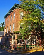
Morton Memorial Library from street

The Morton Memorial Library is an historic structure along Kelly Street in the hamlet of Rhinecliff, New York, just east of the Hudson River.

Excerpt from the Wikipedia article Morton Memorial Library (Rhinecliff, New York) (License: CC BY-SA 3.0, Authors, Images).

Morton Memorial Library (Rhinecliff, New York)
Kelly Street,

Geographical coordinates (GPS) Address Nearby Places
placeShow on map

Wikipedia: Morton Memorial Library (Rhinecliff, New York)Continue reading on Wikipedia

Geographical coordinates (GPS)

Latitude Longitude
N 41.918888888889 ° E -73.951666666667 °
placeShow on map

Address

Kelly Street 81
12574
New York, United States
mapOpen on Google Maps

Morton Memorial Library from street
Share experience

Nearby Places

Rondout Creek
Rondout Creek

Rondout Creek is a 63.3-mile-long (101.9 km) tributary of the Hudson River in Ulster and Sullivan counties, New York, United States. It rises on Rocky Mountain in the eastern Catskills, flows south into Rondout Reservoir, part of New York City's water supply network, then into the valley between the Catskills and the Shawangunk Ridge, where it goes over High Falls and finally out to the Hudson at Kingston, receiving along the way the Wallkill River. The name of Rondout Creek comes from the fort, or redoubt, that was erected near its mouth. The Dutch equivalent of the English word redoubt (meaning a fort or stronghold) is reduyt. In the Dutch records of Wildwyck, however, the spelling used to designate this same fort is invariably Ronduyt during the earliest period, with the present form rondout (often capitalized) appearing as early as November 22, 1666.The Rondout Creek became economically important in the 19th century when the Delaware and Hudson Canal followed closely alongside it from Napanoch to the village of Rondout, now part of Kingston, which grew rapidly as the canal's northern port. Today it is important not only for the reservoir, but for the fishing and other recreational opportunities it provides. Due to the Wallkill, it drains a vast area stretching over 1,100 square miles (2,850 km2) all the way down to Sussex County, New Jersey. The high mountains around its upper course and the reservoir, which collects water from three others, also add to its flow.

Hudson River Historic District

The Hudson River Historic District, also known as Hudson River Heritage Historic District, is the largest Federally designated district on the mainland of the contiguous United States. It covers an area of 22,205 acres (34.6 square miles, 89 km²) extending inland roughly a mile (1.6 km) from the east bank of the Hudson River between Staatsburg and Germantown in Dutchess and Columbia counties in the U.S. state of New York. This area includes the riverfront sections of the towns of Clermont, Red Hook, Rhinebeck and part of Hyde Park. This strip includes in their entirety the hamlets of Annandale, Barrytown, Rhinecliff and the village of Tivoli. Bard College and two protected areas, Margaret Lewis Norrie State Park and Tivoli Bays Unique Area, are also within the district. From the colonial era to the early 20th century, the district was characterized by large "country seats" built by members of the Livingston family, such as Clermont Manor and Montgomery Place, both National Historic Landmarks. For most of that period, these estates were worked by tenant farmers, with much of the rest of the population concentrated in small riverside communities. This semi-feudal arrangement is still reflected in land use and architecture within the district today, since it has not seen major development. In 1990, two separate historic districts were combined and expanded into a National Historic Landmark District (NHLD), in recognition of this unique history and character. Only 2% by acreage of the properties within the district are not considered historic.