place

Puriton

Civil parishes in SomersetSomerset LevelsVillages in Sedgemoor
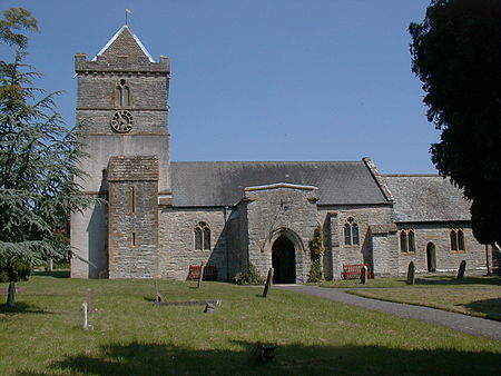
Puriton Church
Puriton Church

Puriton is a village and parish at the westerly end of the Polden Hills, in the Sedgemoor district of Somerset, England. The parish has a population of 1,968. The local parish church is dedicated to St Michael and All Angels. A chapel on Woolavington Road was converted to a private house some 20 years ago. The parish includes the hamlets of Dunball and Down End. In 1996, the village was described as "now becoming a rural commuter village". The built-up area is mostly between 5 and 50 metres above sea level. The village has a full range of facilities, such as a primary school, parish church, pub, post office, butcher and hairdresser. It started to expand considerably in the 1960s and 1970s when new houses were built on former farm land, a former infilled stone Blue Lias quarry, Puriton Park, and on fields between the existing houses. The old Victorian school near the church was converted into homes and a new school built elsewhere. The Manor House was sold in 1960 and four houses were built on its former tennis courts; the House is in multiple occupancy.

Excerpt from the Wikipedia article Puriton (License: CC BY-SA 3.0, Authors, Images).

Puriton
Church Field Lane,

Geographical coordinates (GPS) Address Nearby Places
placeShow on map

Wikipedia: PuritonContinue reading on Wikipedia

Geographical coordinates (GPS)

Latitude Longitude
N 51.172 ° E -2.973 °
placeShow on map

Address

Church Field Lane

Church Field Lane
TA7 8BX
England, United Kingdom
mapOpen on Google Maps

Puriton Church
Puriton Church
Share experience

Nearby Places

Dunball
Dunball

Dunball is a small hamlet west of the village of Puriton and close to the town of Bridgwater, Somerset, England. Just north of Dunball is Down End which is the site of Down End Castle a motte-and-bailey castle, which has been designated as a Scheduled Ancient Monument. Located on the A38, adjacent to Junction 23 of the M5 motorway, it hosts a wharf on the River Parrett, created in 1844 by Bridgwater coal merchants, which is the only part of the Port of Bridgwater still in commercial use today. Dunball also has a small industrial estate, built on the site of the Royal Ordnance Factory's hostel blocks; and a hotel. The wharf was formerly linked to the Bristol and Exeter Railway by a rail track which crossed the A38, on the right hand side of the hotel. The link was built in 1876 by coal merchants, and was originally operated as a horse-drawn tramway. It was removed during the Beeching Axe and Dunball also lost its railway station on 5 October 1964, which had opened in 1873. The wharf was used during World War II to bring Welsh coal to the nearby Royal Ordnance Factory, ROF Bridgwater. The wharf is now used for landing stone products, mainly marine sand and gravels dredged in the Bristol Channel. The King's Sedgemoor Drain drains into the River Parrett at Dunball, adjacent to the wharf, via a clyse. The clyse has been moved from its original location and it now obstructs the entrance to a small harbour adjacent to the wharf. During the Winter flooding of 2013–14 on the Somerset Levels high volume pumps from the Netherlands were installed at Dunball. River silt was dredged from the river in this locality in order to make Bath bricks, an early cleaning material.

Somerset Levels
Somerset Levels

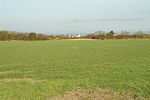
The Somerset Levels are a coastal plain and wetland area of Somerset, England, running south from the Mendips to the Blackdown Hills. The Somerset Levels have an area of about 160,000 acres (650 km2) and are bisected by the Polden Hills; the areas to the south are drained by the River Parrett, and the areas to the north by the rivers Axe and Brue. The Mendip Hills separate the Somerset Levels from the North Somerset Levels. The Somerset Levels consist of marine clay "levels" along the coast and inland peat-based "moors"; agriculturally, about 70 per cent is used as grassland and the rest is arable. Willow and teazel are grown commercially and peat is extracted. A Palaeolithic flint tool found in West Sedgemoor is the earliest indication of human presence in the area. The Neolithic people exploited the reed swamps for their natural resources and started to construct wooden trackways, including the world's oldest known timber trackway, the Post Track, dating from about 3800 BC. The Levels were the location of the Glastonbury Lake Village as well as two Lake villages at Meare Lake. Several settlements and hill forts were built on the natural "islands" of slightly raised land, including Brent Knoll and Glastonbury. In the Roman period sea salt was extracted and a string of settlements were set up along the Polden Hills. The discovery at Shapwick of 9,238 silver Roman coins, known as the Shapwick Hoard, was the second-largest ever found from the time of the Roman Empire. A number of Saxon charters document the incorporation of areas of moor in estates. In 1685, the Battle of Sedgemoor was fought in the Bussex area of Westonzoyland at the conclusion of the Monmouth Rebellion. As a result of the wetland nature of the Levels, the area contains a rich biodiversity of national and international importance. It supports a vast variety of plant and bird species and is an important feeding ground for birds and includes 32 Sites of Special Scientific Interest, of which 12 are also Special Protection Areas. The area has been extensively studied for its biodiversity and heritage, and has a growing tourism industry. People have been draining the area since before Domesday Book. In the Middle Ages, the monasteries of Glastonbury, Athelney and Muchelney were responsible for much of the drainage. The artificial Huntspill River was constructed during the Second World War as a reservoir, although it also serves as a drainage channel. The Sowy River between the River Parrett and King's Sedgemoor Drain was completed in 1972; water levels are managed by the Levels internal drainage boards. During 2009 and 2010 proposals to build a series of electricity pylons by one of two routes between Hinkley Point and Avonmouth, to transmit electricity from the proposed Hinkley Point C nuclear power station, attracted local opposition. Discussions have taken place concerning the possibility of obtaining World Heritage Site status for the Somerset Levels as a "cultural landscape". It was suggested that if this bid were successful it could improve flood control, but only if wetland fens were created again; the plans were abandoned in 2010.

Willow Man
Willow Man

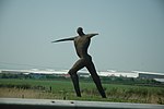
Willow Man is a large outdoor sculpture by Serena de la Hey. It is in a field to the west of the M5 motorway, near Bridgwater in Somerset, South West England, near to the Bristol to Exeter railway line and south of junction 23 of the motorway. It stands 40 feet (12 m), with a 16-foot (5 m) arm span, and is made of black maul willow withies woven over a 3-tonne steel frame.Willow Man was commissioned by South West Arts, for the Year of the Artist, and the Moate family the land owner. The sculpture, which cost £15,000 (equivalent to about £27,000 in 2021), was unveiled in September 2000. It marks the millennium and celebrates the role of willow in the ecology and craft tradition of the Somerset Levels. The first sculpture was burnt down in an arson attack on 8 May 2001. The sculpture was rebuilt by the same artist in October 2001, and a 130-foot (40 m) circular moat was excavated around it as a precaution against further attacks.A notable landmark, it can be described as a somehow permanent Wicker man sculpture. The sculpture is popularly known as Withy Man, or Angel of the South in reference to Antony Gormley's sculpture Angel of the North. The name Angel of the South is now commonly used also as the unofficial title for a proposed colossal sculpture in Ebbsfleet. In September 2006, Willow Man received "a £20,000 hair cut". The sculptor Serena de la Hey said that she thought many local birds had been using the material for their nests. When the artist saw her sculpture she was "shocked to see the wear and tear". In 2018, an appeal to raise funds for the repair of the structure failed to meet its target. By 2021, the structure had further deteriorated with the head and arms having lost form.