Georges River

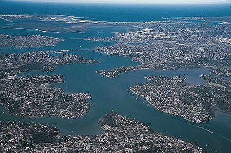
The Georges River, also known as Tucoerah River, is an intermediate tide-dominated drowned valley estuary, that is located in Sydney in the state of New South Wales, Australia. The Georges River is located south and south-west from the Sydney CBD, with the mouth of the river being at Botany Bay. The river travels for approximately 96 kilometres (60 mi) in a north and then easterly direction to its mouth at Botany Bay, about 5 kilometres (3.1 mi) from the Tasman Sea. The Georges River is the main tributary of Botany Bay; with the Cooks River being a secondary tributary. The total catchment area of the river is approximately 930.9 square kilometres (359.4 sq mi) and the area surrounding the river is managed by various local government authorities and NSW Government agencies across Sydney. The land adjacent to the Georges River was occupied for many thousands of years by the Tharawal and Eora peoples. They used the river as an important source of food and a place for trade.
Excerpt from the Wikipedia article Georges River (License: CC BY-SA 3.0, Authors, Images).Georges River
Taren Point Road, Sydney Taren Point
Geographical coordinates (GPS) Address Nearby Places Show on map
Geographical coordinates (GPS)
| Latitude | Longitude |
|---|---|
| N -34.009998333333 ° | E 151.12989983333 ° |
Address
Captain Cook Bridge
Taren Point Road
2229 Sydney, Taren Point
New South Wales, Australia
Open on Google Maps


