place

Polster Valley Wheel House

Lower Saxony geography stubsUpper Harz Water Regale

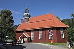
The Polster Valley Wheel House (German: Polstertaler Zechenhaus) lies in the Polster valley about three kilometres from Altenau in the Upper Harz region of Germany and is surrounded by a campsite. The wheel house was built in 1729 and provided power for the pumping station of the Polsterberg Pumphouse (Polsterberger Hubhaus) with two water wheels until the early 20th century.

Excerpt from the Wikipedia article Polster Valley Wheel House (License: CC BY-SA 3.0, Authors).

Polster Valley Wheel House
Hellertal, Harz (LK Goslar)

Geographical coordinates (GPS) Address Phone number Website Nearby Places
placeShow on map

Wikipedia: Polster Valley Wheel HouseContinue reading on Wikipedia

Geographical coordinates (GPS)

Latitude Longitude
N 51.799444444444 ° E 10.416388888889 °
placeShow on map

Address

Waldcampingplatz Polstertal

Hellertal
38707 Harz (LK Goslar)
Lower Saxony, Germany
mapOpen on Google Maps

Phone number

call+4953235582

Website
campingplatz-polstertal.de

linkVisit website

Share experience

Nearby Places

Polsterberg Pumphouse

The Polsterberg Pumphouse (German: Polsterberger Hubhaus) is a pumping station above the Dyke Ditch in the Upper Harz in central Germany which is used today as a forest restaurant. As part of the Upper Harz Water Regale it was built in the 18th century and was used to lift the water needed in Clausthal for the mining industry from the Dyke Ditch (Dammgraben) to the level of the highest pond, the Hirschler Pond. Aside from this water hoist, the Dyke Ditch supplied, and still supplies, water over ditches and tunnels to the Hausherzberg Ponds and the Lower Peacock Pond (Unterer Pfauenteich). The problem was however, that, as it happened, the most productive silver mines in the Upper Harz mining region, the Caroline Pit and the Dorothea Pit, were high up in the mountains and could only be supplied with water power from the Hirschler Pond. The motive force for the wooden piston pumps was won in the Polster valley below by two water wheels. The headrace for these water wheels was brought via the Heller Valley Ditch (Hellertal Graben) from the Heller valley and from the Fortune Pond over its Bottom Ditch (Grundgraben), but frictional losses and poor efficiencies meant that a considerable amount of headrace water was required in order to lift just a few litres of water from the Dyke Ditch. These wheels transferred their output power over 260 and 560 m long flat rods made of wood to the pumping station on the Polsterberg hill. In the pumping station the water from the Dyke Ditch was pumped 8 m higher and fed into drinking troughs from which it was then further transported via the Hutthal Ditch and Huttaler Widerwaage to the Hirschler Pond, or via the Jägersbleek Tunnel and Ditch. The Polsterberg Pumphouse also acted as living accommodation for the master pumper and the ditch keepers, as well as a bar (Schankstube). At the beginning of the 20th century the wooden structures were replaced by electrically-drive pumps; the original can still be seen in the pumphouse by the ditch. Today the building is listed. It is purely run as a restaurant and is a popular destination for walkers from Altenau and Clausthal-Zellerfeld. Like the nearby Sperberhai Dam House it lies on the Harz High Road, the B 242.

Schalke (Harz)
Schalke (Harz)

The Schalke is a mountain, 762 m above sea level (NN), in the Upper Harz in the German state of Lower Saxony. It lies in Goslar district north of Clausthal-Zellerfeld and west of Schulenberg. From 1959 there was a French listening post on the summit, which was supplemented in 1968 by a 64 m high concrete tower. This tower stood empty from 1993 and was demolished on 11 October 2002; the entire facility being removed in September 2003. Other listening posts in the Harz were located on the Wurmberg and the Stöberhai. Towers that still exist include those on the Ravensberg and the Bocksberg, the latter not far from the Schalke. The observation tower, which was about 10.5 m high, stood about 50 metres southeast of the listening post until 2002 and, following the demolition of the latter, was moved back to its original site on the summit. However it only has good views towards the east and south. The view extends from the Brocken past the Wurmberg and Hanskühnenburg to Clausthal-Zellerfeld. Next to the tower stands a shooting hut belonging to the Harz Club and stamp checkpoint no. 125 which is part of the Harzer Wandernadel hiking trail network. The tower is the oldest (built 1892, restored 1992) of four steel observation towers belonging to the Harzklub in the Harz. A road, closed to private cars, runs from the Auerhahn Inn on the B 241 federal highway up to the Schalke. There are also long hiking trails from Zellerfeld and Goslar and a short, steep footpath from Mittelschulenberg past the Lower Schalke Pond and Festenburg, two parishes in Schulenberg, up to the Schalke.