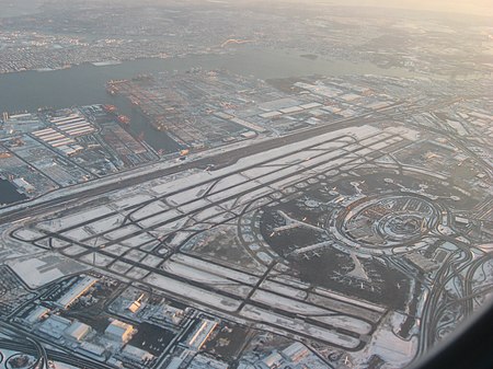
Newark Liberty International Airport

Newark Liberty International Airport (IATA: EWR, ICAO: KEWR, FAA LID: EWR), originally Newark Metropolitan Airport and later Newark International Airport, is an international airport straddling the boundary between the cities of Newark in Essex County and Elizabeth in Union County, New Jersey. Located about 4.5 miles (7.2 km) south of downtown Newark, it is a major gateway to points in Europe, South America, Asia, and Oceania. It is jointly owned by the cities and leased to its operator, the Port Authority of New York and New Jersey. It is the second-busiest airport in the New York airport system, behind John F. Kennedy International Airport but far ahead of LaGuardia Airport. The airport is located 9 miles (14 km) west-southwest of Manhattan in New York City. It is near the Newark Airport Interchange, the junction between Interstate 95 and Interstate 78 (both components of the New Jersey Turnpike), as well as U.S. Routes 1 and 9, which has junctions with U.S. Route 22, Route 81, and Route 21. AirTrain Newark connects the terminals with the Newark Liberty International Airport Station. The station is served by NJ Transit's Northeast Corridor Line and North Jersey Coast Line. Amtrak's Northeast Regional and Keystone Service trains also stop at the station. The City of Newark built the airport on 68 acres (28 ha) of marshland in 1928, and the Army Air Corps operated the facility during World War II. The airport was constructed adjacent to Port Newark and U.S. Route 1. After the Port Authority took it over in 1948, an instrument runway, a terminal building, a control tower, and an air cargo center were added. The airport's Building 51 from 1935 is a National Historic Landmark. During 2022, the airport served 43.4 million passengers, which made it the 29th-busiest airport by passenger traffic in the world. The busiest year to date was 2019 when it served 46.3 million passengers. Newark serves 50 carriers and is the largest hub for United Airlines by available seat miles. The airline serves about 63% of passengers at EWR making it the largest tenant at the airport. United and FedEx Express, its second-largest tenant, operate in three buildings on 2 million square feet [0.19 square kilometers] of airport property.
Excerpt from the Wikipedia article Newark Liberty International Airport (License: CC BY-SA 3.0, Authors, Images).Newark Liberty International Airport
Departures Mezzanine Level, Newark
Geographical coordinates (GPS) Address Nearby Places Show on map
Geographical coordinates (GPS)
| Latitude | Longitude |
|---|---|
| N 40.6925 ° | E -74.168611111111 ° |
Address
Departures Mezzanine Level
07114 Newark
New Jersey, United States
Open on Google Maps


