Möhlintal
Landforms of AargauValleys of Switzerland

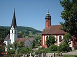
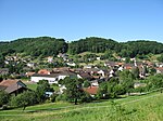
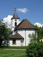
The Möhlintal is a 10-kilometre long valley running between Möhlin and Wegenstetten in the Rheinfelden district of Canton Aargau, Switzerland. The five municipalities in the valley (Möhlin, Zeiningen, Zuzgen, Hellikon and Wegenstetten) have a total population of around 14,000 people. The upper part of the valley is also known as the "Wegenstettertal". This name was particularly used by associations and groups related to the upper Möhlintal municipalities. In Habsburg times the area was known as Landschaft (territory) Möhlinbach. The valley was also sometimes known as the "Chläfflital". The official name of the valley given by Canton Aargau is "Möhlintal".
Excerpt from the Wikipedia article Möhlintal (License: CC BY-SA 3.0, Authors, Images).Möhlintal
Hauptstrasse,
Geographical coordinates (GPS) Address Nearby Places Show on map
Geographical coordinates (GPS)
| Latitude | Longitude |
|---|---|
| N 47.52 ° | E 7.9111111111111 ° |
Address
Hauptstrasse
Hauptstrasse
4315
Aargau, Switzerland
Open on Google Maps


