Corso Italia-Davenport
AC with 0 elementsNeighbourhoods in Toronto

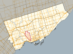
Corso Italia-Davenport is a neighbourhood in central Toronto, Ontario, Canada. Its boundaries, according to the City of Toronto, are the CNR tracks to the west, Morrison Avenue to the north, Westmount Avenue to the east on the northern portion and Oakwood Avenue to the east on the southern portion, and on the south by Davenport Road. Within this official neighbourhood of the City of Toronto are several neighbourhoods, Corso Italia, Davenport, Earlscourt, and Regal Heights.
Excerpt from the Wikipedia article Corso Italia-Davenport (License: CC BY-SA 3.0, Authors, Images).Corso Italia-Davenport
St. Clair Avenue West, Toronto
Geographical coordinates (GPS) Address Nearby Places Show on map
Geographical coordinates (GPS)
| Latitude | Longitude |
|---|---|
| N 43.677 ° | E -79.447 ° |
Address
St. Nicola Di Bari Roman Catholic Church
St. Clair Avenue West
M6E 1B9 Toronto
Ontario, Canada
Open on Google Maps


