place

Tahuya River

Rivers of Kitsap County, WashingtonRivers of Mason County, WashingtonRivers of Washington (state)
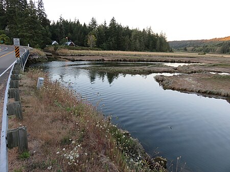
Tahuya estuary North Shore bridge 17 Aug 2017

The Tahuya River is a stream in the U.S. state of Washington. It originates at Tahuya Lake in western Kitsap Peninsula and flows south, emptying into Hood Canal near the Great Bend.

Excerpt from the Wikipedia article Tahuya River (License: CC BY-SA 3.0, Authors, Images).

Tahuya River
Northeast Shorebrook Drive,

Geographical coordinates (GPS) Address Nearby Places
placeShow on map

Wikipedia: Tahuya RiverContinue reading on Wikipedia

Geographical coordinates (GPS)

Latitude Longitude
N 47.370277777778 ° E -123.05138888889 °
placeShow on map

Address

Northeast Shorebrook Drive

Northeast Shorebrook Drive
98588
Washington, United States
mapOpen on Google Maps

Tahuya estuary North Shore bridge 17 Aug 2017
Share experience

Nearby Places

Sund Rock

Sund Rock is a designated conservation area on the U.S. state of Washington's Hood Canal. The area is known for abundant and diverse life, including but not limited to Lingcod, Giant Pacific Octopus, Wolf Eel, as well as nudibranch, anemone, and sea cucumber. The area is well known to regional scuba divers, especially for its two major walls, known colloquially as the north and south walls. These walls have depths 70 to 80 feet (21 to 24 m), depending upon the tide. Several other walls exist, some going down beyond 100 feet (30 m) in depth. One of these is called "fish pen wall." Additional features include the "fish bowl"—a reef-like area full of life—a large sunken boat just to the north of the north wall, and a small wrecked boat between the north and south walls. Recreational and technical divers alike find Sund Rock attractive for various reasons. Recreational divers appreciate Sund Rock because it is not a current-sensitive area, the main walls are easily within recreational dive limits, and for abundant sea life. Technical divers enjoy the deeper walls and other areas that allow them to dive well beyond recreational limits. Because Sund Rock is a conservation area, no hunting or gathering of any kind is permitted. Two ways exist of entering the waters in the area. One option involves a somewhat steep but short hike and surface swim of 250 to 600 metres (820 to 1,970 ft). An alternative method is to access a private beach nearby. The boundaries of the area are

Octopus Hole Conservation Area

Octopus Hole Conservation Area is defined as those waters, tidelands, and bedlands of Hood Canal within a line projected due east from the western shore of Hood Canal on latitude 47°27'01"N for 200 yards, thence southerly 628 yards parallel to the high watermark to latitude 47°26'40", thence due west to shore. Similar to the close-by Sund Rock conservation area, Octopus Hole is very popular with scuba divers who enjoy diving the walls associated with the site to view various underwater creatures, including lingcod, giant Pacific octopus, wolf eel, sea cucumber, and nudibranch. The area is well known to regional scuba divers, especially for its two major walls, known colloquially as the north and south walls. These walls have depths of 70 to 80 feet (21 to 24 m), depending upon the tide. Several other walls exist, some going down beyond 100 feet (30 m) in depth. One of these is called "fish pen wall." Additional features include the "fishbowl"—a reef-like area full of life—a large sunken boat just to the north of the north wall and a small wrecked boat between the north and south walls. An alternative method is to access a private beach nearby. Recreational and technical divers alike find Sund Rock attractive for various reasons. Recreational divers appreciate Sund Rock because it is not a current-sensitive area, the main walls are easily within recreational dive limits, and for abundant sea life. Technical divers enjoy the deeper walls and other areas that allow them to dive well beyond recreational limits. Because Octopus Hole is a conservation area, no hunting or gathering of any kind is permitted. Like most sites on the mid to southern Hood canal, this area is not currently sensitive. However, some noticeable current can occur. Such current is not strong enough to significantly affect dive plans or cause problems, but it is strong enough to slow or speed progress, depending upon the diver's direction.

Mason Lake
Mason Lake

Mason Lake is a natural elongated lake south of Belfair, Washington, United States in Mason County. Named for Charles H. Mason, the first secretary of Washington Territory, the lake is on the isthmus of the Kitsap Peninsula between the Hood Canal and Pickering Passage of the Case Inlet. The smaller Benson Lake is to its eastern side. Mason Lake is approximately 1000 acres in size and four miles long. Its maximum depth is 90 feet and the mean depth is 48 feet. With 10.9 miles of shoreline, the lake sits at 194 feet above sea level. More than a thousand residents live yearlong around the shores of Mason Lake, the second largest freshwater lake in Mason County, second to the man-made Lake Cushman to its northwest. Originally a summer vacation community, the lake has always been known for its power boats, jet skis and water skiing. A county park provides picnic and boat launching access. Swimming is limited to private access parks and residences. The single lane boat launch is on the steeper side and winches tend to get jammed if they're in the locked or retrieval state. Mason Lake is also home to a large amount of wildlife; including bald eagles, ringed-necked pheasants, and robins. It has a variety of ducks also; including mallards, diving ducks, canvasbacks, and ruddy ducks. Otters, divers, killdeer, and great blue herons also inhabit Mason Lake. Fish include; Rainbow trout, largemouth bass, yellow perch, brown bullhead catfish, and northern pikeminnow. The community of Mason Lake is located centrally between Grapeview and Harstine Island to the east, and Twanoh State Park to the west. Much of the area surrounding Mason Lake is commercial timberland in various states of harvest.