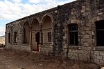
Sabalan, Safad
Arab villages depopulated during the 1948 Arab–Israeli WarDistrict of SafadDruze holy placesReligious buildings and structures in IsraelZiyarat

Sabalan (Arabic: سبلان, Sabalân) was a Palestinian Arab village in the Safad Subdistrict, located 15.5 kilometers (9.6 mi) northwest of Safad. It stood at an elevation of 800 meters (2,600 ft) above sea level overlooking the Druze village of Hurfeish (now a Druze town). In 1945, Sabalan had a population of 70. It was depopulated during the 1948 Palestine War.
Excerpt from the Wikipedia article Sabalan, Safad (License: CC BY-SA 3.0, Authors, Images).Sabalan, Safad
89, Hurfeish
Geographical coordinates (GPS) Address Nearby Places Show on map
Geographical coordinates (GPS)
| Latitude | Longitude |
|---|---|
| N 33.011666666667 ° | E 35.341388888889 ° |
Address
89
Hurfeish
North District, Israel
Open on Google Maps


