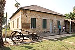
Sirin, Baysan
Ancient Samaritan settlementsArab villages depopulated during the 1948 Arab–Israeli WarPages with non-numeric formatnum arguments

Sirin (Arabic: سرين), was a Palestinian Arab village located 17 kilometers (11 mi) north of Beisan. The village was depopulated and destroyed in 1948. Only the village cemetery and one house remain standing, along with the remains of a mosaic pavement and a vaulted spring dating to the Byzantine period. Mentioned in historical documents, the 1596 census indicated it had 45 households; by 1945, the number of inhabitants had risen to 810.
Excerpt from the Wikipedia article Sirin, Baysan (License: CC BY-SA 3.0, Authors, Images).Sirin, Baysan
Emek HaYarden Regional Council
Geographical coordinates (GPS) Address Nearby Places Show on map
Geographical coordinates (GPS)
| Latitude | Longitude |
|---|---|
| N 32.663333333333 ° | E 35.509166666667 ° |
Address
מועצה אזורית עמק הירדן
Emek HaYarden Regional Council
North District, Israel
Open on Google Maps


