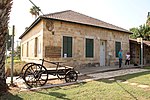
Awlam
Arab villages depopulated prior to the 1948 Arab–Israeli WarDistrict of TiberiasPages with non-numeric formatnum arguments

Awlam (Arabic: عولم) was a Palestinian village 15 kilometres (9.3 mi) south of Tiberias situated on the slopes of the westward Wadi Awlam.
Excerpt from the Wikipedia article Awlam (License: CC BY-SA 3.0, Authors, Images).Awlam
Derekh HaHar,
Geographical coordinates (GPS) Address Website Nearby Places Show on map
Geographical coordinates (GPS)
| Latitude | Longitude |
|---|---|
| N 32.666388888889 ° | E 35.499166666667 ° |
Address
עין אולם
Derekh HaHar
North District, Israel
Open on Google Maps


