place

Downtown Portland, Oregon

Central business districts in the United StatesEconomy of Portland, OregonNeighborhoods in Portland, Oregon
Portland, Oregon skyline from the Ross Island Bridge

Downtown Portland is the central business district of Portland, Oregon, United States. It is on the west bank of the Willamette River in the northeastern corner of the southwest section of the city and where most of the city's high-rise buildings are found. The downtown neighborhood extends west from the Willamette to Interstate 405 and south from Burnside Street to just south of the Portland State University campus (also bounded by I-405), except for a part of northeastern portion north of SW Harvey Milk Street and east of SW 3rd Ave that belongs to the Old Town Chinatown neighborhood. High-density business and residential districts near downtown include the Lloyd District, across the river from the northern part of downtown, and the South Waterfront area, just south of downtown in the South Portland neighborhood. Portland's downtown features narrow streets—64 feet (20 m) wide—and square, compact blocks 200 feet (61 m) on a side, to create more corner lots that were expected to be more valuable. The small blocks also made downtown Portland pleasant to walk through. The 264-foot (80 m) long combined blocks divide one mile (1.6 km) of road into exactly 20 separate blocks. By comparison, Seattle's blocks are 240 by 320 feet (73 m × 98 m), and Manhattan's east–west streets are divided into blocks that are from 600–800 feet (183–244 m) long.

Excerpt from the Wikipedia article Downtown Portland, Oregon (License: CC BY-SA 3.0, Authors, Images).

Downtown Portland, Oregon
Southwest Broadway, Portland Downtown

Geographical coordinates (GPS) Address Nearby Places
placeShow on map

Wikipedia: Downtown Portland, OregonContinue reading on Wikipedia

Geographical coordinates (GPS)

Latitude Longitude
N 45.51935 ° E -122.67962 °
placeShow on map

Address

Southwest Broadway

Southwest Broadway
97204 Portland, Downtown
Oregon, United States
mapOpen on Google Maps

Portland, Oregon skyline from the Ross Island Bridge
Share experience

Nearby Places

Pioneer Square South and Pioneer Square North stations

Pioneer Square South and Pioneer Square North are a pair of light rail stations in Portland, Oregon, United States, served by TriMet as part of the MAX Light Rail system. Situated directly west of the Portland Transit Mall on the perimeter of Pioneer Courthouse Square in downtown Portland, facing Yamhill and Morrison streets between Broadway and 6th Avenue, the pair are the 21st and 7th stations eastbound on the Blue Line and the Red Line, respectively. They consist of one side platform each as MAX operates in a one-way pair along this segment; trains traveling eastbound stop at Pioneer Square South while trains traveling westbound stop at Pioneer Square North. With connections to the Green, Orange, and Yellow lines, the Pioneer Square stations, along with the Pioneer Courthouse/Southwest 6th and Pioneer Place/Southwest 5th stations located one block east, mark the only transfer point in the MAX system where riders can board any of the five existing lines. The Pioneer Square stations are among the 27 original stations of the Banfield Light Rail Project, which built the Metropolitan Area Express (MAX), Portland's first light rail line. They opened along with the inaugural service of MAX on September 5, 1986. The stations are currently served by the Blue Line, which operates between Hillsboro and Gresham, and the Red Line, which operates between Beaverton and Portland International Airport. The Yellow Line had served the stations from May 2004 until that line's rerouting to the Portland Transit Mall in August 2009.

Portland Transit Mall

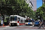
The Portland Transit Mall is a 1.2-mile (1.9 km) public transit corridor that travels north–south through the center of downtown in Portland, Oregon, United States. It comprises a pair of one-way streets—6th Avenue for northbound traffic and 5th Avenue for southbound—along which two of three lanes are restricted to transit buses and light rail vehicles only. As of September 2022, the corridor is served by the Green, Orange, and Yellow lines of MAX Light Rail; Frequent Express; and over a dozen local bus routes, all of which are services of TriMet, the transit agency operating within the Oregon side of the Portland metropolitan area. C-Tran, the transit agency for Clark County, Washington, additionally serves it with two express bus routes—#105 I-5 Express and #164 Fisher’s Landing Express.The transit mall was conceived as part of Portland's 1972 Downtown Plan. It opened in 1977 and until light rail trains were added in 2009, buses were the only transit vehicles using it. The mall was rebuilt and extended southwards from 2007 to 2009, and it reopened for buses on May 24, 2009. Light rail service on the mall was introduced on August 30, 2009, with the shifting of the MAX Yellow Line to the mall from its original routing in downtown, and a second MAX line, the Green Line, began serving the mall two weeks later, on September 12. Between fall 2009 and July 2014, the Portland Vintage Trolley also served the transit mall on certain Sundays. In September 2015, the new MAX Orange Line replaced the Yellow Line service in the southbound direction on the mall, on 5th Avenue, with the Orange and Yellow lines being through-routed at all times.