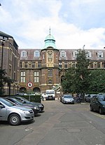
Downing Street, Cambridge
Downing College, CambridgeHistory of CambridgeMuseum districts in the United KingdomStreets in CambridgeUse British English from August 2017

Downing Street is a street in central Cambridge, England. It runs between Pembroke Street and Tennis Court Road at the western end and a T-junction with St Andrew's Street at the eastern end. Corn Exchange Street and St Tibbs Row lead off to the north. Downing Place leads off to the south. To the north at the western end is the New Museums Site of the University of Cambridge. To the south is the Downing Site of the University. Many of the University's departments are located here. Downing Place United Reformed Church (St Columba's) is on the corner with Downing Place.
Excerpt from the Wikipedia article Downing Street, Cambridge (License: CC BY-SA 3.0, Authors, Images).Downing Street, Cambridge
Corn Exchange Street, Cambridge Petersfield
Geographical coordinates (GPS) Address Nearby Places Show on map
Geographical coordinates (GPS)
| Latitude | Longitude |
|---|---|
| N 52.203 ° | E 0.122 ° |
Address
Downing Site (University of Cambridge)
Corn Exchange Street
CB2 3EQ Cambridge, Petersfield
England, United Kingdom
Open on Google Maps


