Edgware Road

Edgware Road is a major road in London, England. The route originated as part of Roman Watling Street and, unusually in London, it runs for 10 miles in an almost perfectly straight line. Forming part of the modern A5 road, Edgware Road undergoes several name changes along its length, including Maida Vale, Kilburn High Road, Shoot Up Hill and Cricklewood Broadway; but the road is, as a whole, known as the Edgware Road, as it is the road to Edgware. The road runs from central to suburban London, beginning at Marble Arch in the City of Westminster and heading north to Edgware in the London Borough of Barnet. It is used as the boundary for four London boroughs: Harrow and Brent to the west, and Barnet and Camden to the east.
Excerpt from the Wikipedia article Edgware Road (License: CC BY-SA 3.0, Authors, Images).Edgware Road
Bayswater Road, London Marylebone
Geographical coordinates (GPS) Address Nearby Places Show on map
Geographical coordinates (GPS)
| Latitude | Longitude |
|---|---|
| N 51.5133 ° | E -0.1604 ° |
Address
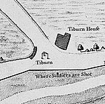
Site of the Tyburn Tree
Bayswater Road
W2 2ET London, Marylebone
England, United Kingdom
Open on Google Maps


