place

Beaver Hills, New Haven

Connecticut geography stubsNeighborhoods in New Haven, Connecticut

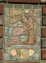
Beaver Hills is a neighborhood in the city of New Haven, Connecticut. The older, east central portion of the neighborhood is listed on the National Register of Historic Places as the Beaver Hills Historic District. The southwest portion is a state historic district called the Fairlawn-Nettleton Historic District.The name “Beaver Hills” dates to the Colonial era, when it was a piece of high ground near several "beaver ponds". Geologist James Dwight Dana later attributed the "Beaver Pond" to natural springs, rather than the activity of beavers.The Beaver Hills Historic District covers 97 acres (39 ha) of the neighborhood north of Goffe Street and east of Ella Grasso Boulevard. It was listed on the National Register of Historic Places in 1986 and included 235 contributing buildings. The listing recognized the district's significance as a nearly intact example of an early 20th-century suburban residential subdivision. The district in 1986 was composed mostly of single-family homes built between 1908 and 1936. One feature of note was the presence of "one of the city's best collections of early 20th-century garages." The district includes brick gateway piers at the intersections of Goffe Terrace with Norton Parkway and with Ellsworth Avenue, at the south end of the district. The piers include "tile plaques depicting beavers" and "were constructed by the Beaver Hills Company in 1908 to define the southern terminus of the neighborhood." Significant contributing properties in the historic district include the Pitkin House (1931 Tudor Revival style house at 207 Colony Road) and the Alan Krevit House (1936 Colonial Revival style house at 186 Colony Road)

Excerpt from the Wikipedia article Beaver Hills, New Haven (License: CC BY-SA 3.0, Authors).

Beaver Hills, New Haven
Stimson Road, New Haven

Geographical coordinates (GPS) Address Nearby Places
placeShow on map

Wikipedia: Beaver Hills, New HavenContinue reading on Wikipedia

Geographical coordinates (GPS)

Latitude Longitude
N 41.325 ° E -72.947 °
placeShow on map

Address

Beaver Hills Historic District

Stimson Road
06511 New Haven
Connecticut, United States
mapOpen on Google Maps

Share experience

Nearby Places

Beaver Hills Historic District

The Beaver Hills Historic District is a 97-acre (39 ha) historic district in the Beaver Hills neighborhood of New Haven, Connecticut. It was listed on the National Register of Historic Places in 1986. In 1986, it included 235 contributing buildings.According to its 1986 nomination, the district is significant as a nearly intact example of an early 20th-century suburban residential subdivision. The district in 1986 was composed mostly of single-family homes built between 1908 and 1936. The most common architectural styles are Colonial Revival, Tudor Revival and Bungalow. Queen Anne, Spanish Colonial Revival, Prairie and other styles are also represented. One feature of note was the presence of "one of the city's best collections of early 20th-century garages."Significant contributing properties in the historic district include: Pitkin House, from 1931, a Tudor Revival style house at 207 Colony Road. A 2+1⁄2-story "frame house with gable roof, front gable pavilions, stuccoed/half-timbered exterior" (see NRHP-nomination-accompanying photo #22): 21 Alan Krevit House, from 1936, a 2+1⁄2-story Colonial Revival style frame house with gable roof, at 186 Colony Road: 20 The district includes brick gateway piers at the intersections of Goffe Terrace with Norton Parkway and with Ellsworth Avenue, at the south end of the district. The piers include "tile plaques depicting beavers" and "were constructed by the Beaver Hills Company in 1908 to define the southern terminus of the neighborhood." (see photo #13): 2 

Edgewood Park Historic District

Edgewood Historic District is a historic district located in the west-central portion of New Haven, Connecticut. It was listed on the National Register of Historic Places in 1986. A predominantly residential area roughly bisected by Edgewood Avenue, a broad boulevard which features a large central esplanade and forms the principal east-west artery through the heart of the district. The area includes 232 contributing buildings, 4 other contributing structures, and 1 contributing object. Most of these were built between about 1888 and 1900, and represent the city's first neighborhood planned under the tenets of the City Beautiful movement. They are generally either Queen Anne or Colonial Revival in style, and are set (especially on the boulevard-like Edgewood Avenue) on larger lots. The district's most notable topographical feature is the West River, which runs through Edgewood Park in the eastern end of the district on a north-south axis. From the West River, the landscape rapidly rises about forty feet to Yale Avenue on the west. Edgewood Park also includes memorials for the Spanish–American War and the Holocaust. The park's current layout was designed in 1910 by Frederick Law Olmsted Jr. The district includes the central portion of the Edgewood neighborhood, which is generally the area bounded by Whalley Avenue, Sherman Avenue, Chapel Street, and Edgewood Park. The district also borders the Dwight Street Historic District on the east.Edgewood Avenue and is served by route 246 of Connecticut Transit New Haven. The main north-south road is Ella Grasso Boulevard (Route 10).