place

Mashapaug Lake

Lakes of Tolland County, ConnecticutNipmuck State ForestProtected areas of Tolland County, ConnecticutReservoirs in ConnecticutUnion, Connecticut
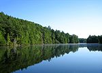
Bigelow Hollow State Park view north from southern shore of Mashapaug Pond

Mashapaug Lake is a 297-acre (1.20 km2) lake surrounded by Bigelow Hollow State Park and Nipmuck State Forest in the town of Union in northeastern Connecticut. The lake has a maximum depth of 39.5 feet (12.0 meters), and an average depth of 15 feet (4.6 meters). Its normal surface elevation is 706 feet (215 m). The lake is very popular with fishermen and boaters from the area, and can also be used for swimming.

Excerpt from the Wikipedia article Mashapaug Lake (License: CC BY-SA 3.0, Authors, Images).

Mashapaug Lake
Crawford Drive,

Geographical coordinates (GPS) Address External links Nearby Places
placeShow on map

Wikipedia: Mashapaug LakeContinue reading on Wikipedia

Geographical coordinates (GPS)

Latitude Longitude
N 42.0167 ° E -72.1333 °
placeShow on map

Address

Mashapaug Pond

Crawford Drive
01521
Connecticut, United States
mapOpen on Google Maps

linkWikiData (Q6783081)
linkOpenStreetMap (12398611)

Bigelow Hollow State Park view north from southern shore of Mashapaug Pond
Share experience

Nearby Places

New England Confederation

The United Colonies of New England, commonly known as the New England Confederation, was a confederal alliance of the New England colonies of Massachusetts Bay, Plymouth, Saybrook (Connecticut), and New Haven formed in May 1643. Its primary purpose was to unite the Puritan colonies in support of the church, and for defense against the American Indians and the Dutch colony of New Netherland. It was the first milestone on the long road to colonial unity and was established as a direct result of a war that started between the Mohegan and Narragansett Indian tribes. Its charter provided for the return of fugitive criminals and indentured servants, and served as a forum for resolving inter-colonial disputes. In practice, none of the goals were accomplished.The confederation was weakened in 1654 after Massachusetts Bay refused to join an expedition against New Netherland during the First Anglo-Dutch War, although it regained importance during King Philip's War in 1675. It was dissolved after numerous colonial charters were revoked in the early 1680s. John Quincy Adams remarked at a meeting of the Massachusetts Historical Society on the 200th anniversary of the Confederation's founding: The New England confederacy was destined to a life of less than forty years' duration. Its history, like that of other confederacies, presents a record of incessant discord-of encroachments by the most powerful party upon the weaker members, and of disregard, by all the separate members, of the conclusions adopted by the whole body. Still the main purpose of the union was accomplished.

Natchaug Trail
Natchaug Trail

The Natchaug Trail is a Blue-Blazed hiking trail "system" which meanders through 19.5 miles (31.4 km) of forests in northeast Connecticut—primarily in Windham County. It is maintained by the Connecticut Forest and Park Association. Its southern trailhead begins in the James L. Goodwin State Forest in the towns of Chaplin, Connecticut and Hampton, Connecticut and the northern terminus is at its intersection with the Nipmuck Trail in Natchaug State Forest in Eastford, Connecticut. For much of its length the Natchaug Trail travels through two Connecticut state forests—the James L. Goodwin State Forest and Natchaug State Forest as well as the much smaller Nathaniel Lyons Memorial Park. Camping permits may be obtained by backpackers for both state forests. In addition to the Nipmuck Trail there are several smaller hiking trails which connect to the Natchaug Trail as well as several park and forest roads and the multi-use Airline State Park Linear Trail. In Natchaug State Forest the CCC Trail is a historic loop trail which was built by the Civilian Conservation Corps during the Great Depression in the 1930s. Two of the several trails inside the James L. Goodwin State Forest are connected to the Natchaug Trail have recently been blazed as official CFPA trails. According to signs at the James L. Goodwin State Forest the White Trail is being (or has been) re-blazed as a blue-white trail named the "Pine Acres Lake View Trail". A CFPA blue-orange blazed trail also intersects with the Natchaug Trail during the stretch between Pine Acres Lake and Black Spruce Pond.

Union Green Historic District

The Union Green is the town green of the New England town of Union, Connecticut. The Green is a small town-owned wedge at the north end of a triangle park area (known as Union Grove) formed by Town Hall Road, Buckley Highway and Kinney Hollow Road. The Green, Union Grove, and properties to the north along Route 190 are listed on the National Register of Historic Places as the Union Green Historic District. The historic district contains 16 buildings, 3 sites, and 2 objects over an area of 300 acres (1.2 km2).The Old Town Hall (now a historical society museum) is the dominant feature on the Green. Several town buildings, specifically the former town hall, library, Congregational Church, the Union School and former district school, and cemetery, are located around the Green. There are only two houses located around the immediate perimeter of Union Green. The oldest is the one built by Ezra Horton in 1759. The other is a newer house constructed in 1956.Although the larger Union Grove to the west of the green is privately owned, it is used for public celebrations. Also in the Grove near the intersection of Kinney Hollow and Town Hall Roads is a rough-hewn granite slab with a bronze commemorative plaque honoring the site of the first meetinghouse.In addition to serving a commemorative function, the green is used as a meeting place for parades and other town events. An Old Home Day celebration is held at the pavilion on the third weekend of August when there is a barbecue and an evening dance.The green and surrounding buildings are significant as a historic district for their evoking "the location's historic role as the town's political, religious, educational and social center", for preserving examples of architecture, and for 18th century stonecarved funerary art included in the cemetery.: 9