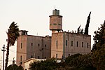
Al-Nabi Yusha'
Arab villages depopulated during the 1948 Arab–Israeli WarDistrict of SafadIslamic shrines in IsraelPages with non-numeric formatnum argumentsShia shrines ... and 1 more
Tegart forts

Al-Nabi Yusha' (Arabic: النبي يوشع was a small Palestinian village in the Galilee situated 17 kilometers to the northeast of Safad, with an elevation of 375 meters above sea level. It was part of the French mandate of Lebanon but was then later transferred and became part of the Palestine Mandate under British control from 1923 until 1948, when it was depopulated during the 1948 Arab-Israeli War. The village was surrounded by forest land overlooking the Hula Valley.
Excerpt from the Wikipedia article Al-Nabi Yusha' (License: CC BY-SA 3.0, Authors, Images).Al-Nabi Yusha'
899, Mevoot HaHermon Regional Council
Geographical coordinates (GPS) Address Nearby Places Show on map
Geographical coordinates (GPS)
| Latitude | Longitude |
|---|---|
| N 33.112777777778 ° | E 35.556111111111 ° |
Address
899
Mevoot HaHermon Regional Council
North District, Israel
Open on Google Maps


