place

Leith Valley

Leith ValleySuburbs of DunedinUse New Zealand English from December 2021Valleys of Otago
Woodhaugh
Woodhaugh

Leith Valley is a suburb, valley, and general area of the New Zealand city of Dunedin, located to the northwest of the city centre. To differentiate the name of the valley from that of the suburb, the former is usually referred to as the Leith Valley, the latter simply as Leith Valley.

Excerpt from the Wikipedia article Leith Valley (License: CC BY-SA 3.0, Authors, Images).

Leith Valley
Malvern Street, Dunedin Woodhaugh

Geographical coordinates (GPS) Address Nearby Places
placeShow on map

Wikipedia: Leith ValleyContinue reading on Wikipedia

Geographical coordinates (GPS)

Latitude Longitude
N -45.8451 ° E 170.5065 °
placeShow on map

Address

Malvern Street

Malvern Street
9010 Dunedin, Woodhaugh
Otago, New Zealand
mapOpen on Google Maps

Woodhaugh
Woodhaugh
Share experience

Nearby Places

Maori Hill
Maori Hill

Māori Hill is a residential suburb of the New Zealand city of Dunedin. It is located at the northern end of the ridge which runs in a crescent around the central city's western edge, 2 kilometres (1.2 mi) to the northwest of the city centre, immediately above and within the Town Belt. It is connected to Dunedin North, which lies to the east, via Drivers Road, the suburbs of Roslyn and Kaikorai to the southwest via Highgate, and the suburb of Wakari to the northwest via Balmacewen Road. 
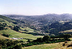
In the northeast of the suburb lies the recreational ground of Prospect Park, and this part of Māori Hill is also often known by this name. From Prospect Park, views across the lower Leith Valley can be obtained, as the park sits close to the edge of cliffs which rise above the broad canyon at Woodhaugh. A steep walking track, the Bullock Track, links the two suburbs. 
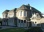
Māori Hill is regarded as one of the city's wealthier and more exclusive suburbs, and contains many fine houses, especially in the maze of winding streets which run through the bush-clad slopes of the Town Belt. These houses include the historic manor Olveston, which has been owned by the city and open to the public since the 1960s. Unlike neighbouring hill suburbs like Roslyn, Māori Hill was not served by a cable car, possibly underlying its greater degree of exclusivity. Notable features of Māori Hill include the Balmacewen Golf Course, home of the Otago Golf Club, in the suburb's northwest. This is one of New Zealand's oldest and finest courses. A state integrated Presbyterian boys' secondary school, John McGlashan College, is located close to the golf course. To the southeast of the course lies a recreation ground, Bishopscourt, and nearby is Balmacewen Intermediate School. As with Prospect Park, this area is often referred to as a separate suburb, Balmacewen, named after the residence of early settler John McGlashan, whose wife's maiden name was McEwen. To the northwest of the golf course is an area of scenic reserve which surrounds the Ross Creek Reservoir in Glenleith. Several popular walking tracks lead down to the reservoir from Cannington Road, which marks the northern edge of Māori Hill. Other schools in Māori Hill include Māori Hill School, a state primary school. On the Roslyn/Kaikorai/Māori Hill border is Columba College, a state integrated Presbyterian girls secondary school, with a coeducational Junior (primary) school. Māori Hill contains the city's largest private hospitals. Formerly known as the Mater Misericordiae, it is now the Mercy Hospital, and contains as part of its complex the Marinoto Clinic. This is located on Newington Avenue, one of several streets which wind down into the Town Belt from Highgate. The hospital is built around Marinoto, the former home of the Sargood family and now one of the hospital's major buildings.

Lindsay Creek
Lindsay Creek

The Lindsay Creek is a tributary of the Water of Leith which runs through the northern suburbs of Dunedin, New Zealand. The Māori name Puke-haukea has been attributed to the creek; however, as puke means a hill, not a watercourse, this is likely to be a confusion. The creek has its origins on the southern slopes of Kapukataumahaka Mount Cargill about 1 kilometre southwest of the summit, and flows south, passing through the popular recreation reserve of Bethunes Gully before reaching Dunedin's suburban area at Normanby. It continues south-southwest, its thalweg running through North East Valley, passing through Chingford Park and along the foot of the Valley's Quarry Gardens before reaching the coastal plain of the Leith at The Gardens Corner. From here, it flows into Dunedin Botanic Gardens where it joins Ōwheo, the Water of Leith. Several measures are underway to widen the channel of the creek at various points, in an attempt to provide more protection against floods. The creek has flooded on numerous occasions, most significantly in the Leith Flood of 1929 and in 1955, when it led to the inundation of many properties in North East Valley. Protection works have been built over the years, most notably realignment and walling of the channel in the lower part of North East Valley after the 1929 flood and further work on the same area in 1965. Further walling of the channel in the central part of North East Valley was undertaken during the 1970s.

Salmond College
Salmond College

Salmond College is a residential college affiliated to the University of Otago in Dunedin, New Zealand. As an affiliated college, it is privately owned and is run independently from the university, being governed by The Council of Knox College and Salmond College, a body with links to the Presbyterian Church of Aotearoa New Zealand. The college was opened in 1971 as Salmond Hall, originally to accommodate women students, to parallel the male-only facility Knox College. It became a coeducational facility during the 1970s. The name was changed to Salmond College in 2006. Salmond and Knox share different parts of the same 4.57 hectare landscaped site (11 acres), located on the north side of the Dunedin Botanic Gardens, close to the area known simply as The Gardens Corner at the foot of North East Valley, approximately 15 minutes walk north of the campus. The site was originally the location for stables for Ross and Glendining Limited, and was donated by the Ross family. The college predominantly provides for first year students, with 40-50 returning for a second year. The college was named after James Salmond, for many years a lecturer at Knox Theological Hall, and his sister Mary Salmond, Principal of the Presbyterian Church's Deaconess Training School in the 1950s. The majority of students are housed in single rooms on one of the four levels in the main building. RLs, known at Salmond “Residential Leaders” are also students who live on site and mentor and support the first year residents. Both the Head and Deputy Head of College reside on the premises. Facilities include a gym, computing facilities, tutorial rooms, a library, television/recreation areas, dining hall, chapel, car-parking, and secure cycle storage. During the summer of 2014/2015 Salmond College was extensively refurbished, creating rooms for up to 261 residents. All bedrooms were be double glazed with new carpet and joinery throughout the College. The College introduced a key card system. President of Salmond College for 2021 is Harry Tran. Harry, who hails from Hastings in Hawke's Bay, returns in 2020 having completed First Year Health Science in 2020 at the University of Otago. Salmond's motto which can be seen in the college crest is 'Gratia et Veritas', or 'Grace and Truth'. At the end of 2020 a whakatauākī was confirmed as a part of the mission statement for the college: Ko te toa i a tini, i a mano o te takata - It is the bravery of a multitude, of thousands of people. This Ngāi Tahu whakatauākī, attributed to Tū Whakauika & Te Oreorehua, refers to the strength of collectivity. As Salmond enters its 50th year in 2021, it reminds us of the power of a living community stretching back several generations, and fosters hope as we continue to grow a community with a shared identity.