place

Caroline Freeman College, Otago

Buildings and structures of the University of Otago
CFCStreetscape
CFCStreetscape

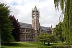
Caroline Freeman College is a residential college owned and operated by the University of Otago in Dunedin, New Zealand. The college is located a short distance north of the Otago central campus near the Dunedin Botanical Gardens.

Excerpt from the Wikipedia article Caroline Freeman College, Otago (License: CC BY-SA 3.0, Authors, Images).

Caroline Freeman College, Otago
Howe Street, Dunedin North Dunedin

Geographical coordinates (GPS) Address Nearby Places
placeShow on map

Wikipedia: Caroline Freeman College, OtagoContinue reading on Wikipedia

Geographical coordinates (GPS)

Latitude Longitude
N -45.858969444444 ° E 170.51523888889 °
placeShow on map

Address

Caroline Freeman College

Howe Street
9016 Dunedin, North Dunedin
Otago, New Zealand
mapOpen on Google Maps

CFCStreetscape
CFCStreetscape
Share experience

Nearby Places

Lindsay Creek
Lindsay Creek

The Lindsay Creek is a tributary of the Water of Leith which runs through the northern suburbs of Dunedin, New Zealand. The Māori name Puke-haukea has been attributed to the creek; however, as puke means a hill, not a watercourse, this is likely to be a confusion. The creek has its origins on the southern slopes of Kapukataumahaka Mount Cargill about 1 kilometre southwest of the summit, and flows south, passing through the popular recreation reserve of Bethunes Gully before reaching Dunedin's suburban area at Normanby. It continues south-southwest, its thalweg running through North East Valley, passing through Chingford Park and along the foot of the Valley's Quarry Gardens before reaching the coastal plain of the Leith at The Gardens Corner. From here, it flows into Dunedin Botanic Gardens where it joins Ōwheo, the Water of Leith. Several measures are underway to widen the channel of the creek at various points, in an attempt to provide more protection against floods. The creek has flooded on numerous occasions, most significantly in the Leith Flood of 1929 and in 1955, when it led to the inundation of many properties in North East Valley. Protection works have been built over the years, most notably realignment and walling of the channel in the lower part of North East Valley after the 1929 flood and further work on the same area in 1965. Further walling of the channel in the central part of North East Valley was undertaken during the 1970s.