place

Long Path

Hiking trails in New JerseyHiking trails in New York (state)Long-distance trails in the United StatesPalisades Interstate Park systemRamapos
Tourist attractions in Bergen County, New JerseyTourist attractions in Greene County, New York
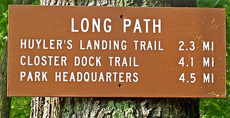
Long Path sign
Long Path sign

The Long Path is a 357-mile (575 km) long-distance hiking trail beginning in New York City, at the West 175th Street subway station near the George Washington Bridge and ending at Altamont, New York, in the Albany area. While not yet a continuous trail, relying on road walks in some areas, it nevertheless takes in many of the popular hiking attractions west of the Hudson River, such as the New Jersey Palisades, Harriman State Park, the Shawangunk Ridge and the Catskill Mountains. It offers hikers a diversity of environments to pass through, from suburbia and sea-level salt marshes along the Hudson to wilderness and boreal forest on Catskill summits 4,000 feet (1,220 m) in elevation. When conceived in the 1930s, it was to be the antithesis of a hiking trail, with neither a designated route nor blazes, simply a list of points of interest hikers could find their own routes to. However, increasing development after World War II in Orange and Rockland counties made that less workable, and it was revived in the 1960s as a standard trail. Work to extend the trail into the Adirondacks is currently underway.

Excerpt from the Wikipedia article Long Path (License: CC BY-SA 3.0, Authors, Images).

Long Path
Ramapo Valley Road,

Geographical coordinates (GPS) Address Nearby Places
placeShow on map

Wikipedia: Long PathContinue reading on Wikipedia

Geographical coordinates (GPS)

Latitude Longitude
N 41.100472 ° E -74.158444 °
placeShow on map

Address

Ramapo Valley Road 150
07430
New Jersey, United States
mapOpen on Google Maps

Long Path sign
Long Path sign
Share experience

Nearby Places

Suffern station
Suffern station

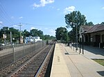
Suffern station is a railroad station in the village of Suffern. The station, located on Ramapo Avenue in Suffern, services trains of New Jersey Transit's Main Line and Metro-North Railroad's Port Jervis Line. Suffern station serves as the terminal for Main Line trains, as trains continue north into Hillburn Yard. The next Main Line station, located in New Jersey, is Mahwah. The next Port Jervis Line station to the north is Sloatsburg. The station consists of two low-level side platforms for trains in both directions, neither of which are handicap accessible for the Americans with Disabilities Act of 1990. Railroad service in Suffern began with the construction of the New York and Erie Railroad in 1841 on land owned by the family of local settler John Suffern of Antrim, Ireland. As part of the generosity, the station at New Antrim was named Suffern in their honor. Regular passenger service in the area began on September 23, 1841 between Goshen and Piermont. Railroad service through Suffern changed on October 19, 1848 when the Paterson and Ramapo Railroad opened for passenger service, resulting in the standing Suffern station becoming part of a branch of the railroad instead of the main line. A new station was built in 1862 to help serve the two lines better. This was replaced on March 9, 1887 between the junction of the Erie Railroad main line and the Piermont Branch. The railroad replaced this station on New Year's Day of 1941 with the current structure.