place

Stevenson Dam Bridge

Arch bridges in the United StatesBridges in Fairfield County, ConnecticutBridges over the Housatonic RiverBuildings and structures in Monroe, ConnecticutConcrete bridges in the United States
Monroe, ConnecticutOxford, ConnecticutRoad bridges in Connecticut
Stevenson Dam Lake Zoar

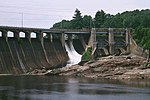
The Stevenson Dam Bridge carries Connecticut Route 34 over the Housatonic River in the U.S. state of Connecticut, connecting the town of Monroe to the town of Oxford. The Stevenson Dam Bridge sits on top of the Stevenson Dam, constructed by the Connecticut Light and Power Company. It is a concrete span featuring 24 arches. The current bridge was constructed in 1919 and is 1213 feet in length by 42 feet in width, featuring one lane in each direction for automotive traffic. It is the only highway bridge in Connecticut on a dam spillway. In 2009, the DOT estimated the dam carries approximately 10,300 vehicles per day.It has been claimed to be one of two dams in the country with a public road over top, but this is false.

Excerpt from the Wikipedia article Stevenson Dam Bridge (License: CC BY-SA 3.0, Authors, Images).

Stevenson Dam Bridge
Roosevelt Drive,

Geographical coordinates (GPS) Address Nearby Places
placeShow on map

Wikipedia: Stevenson Dam BridgeContinue reading on Wikipedia

Geographical coordinates (GPS)

Latitude Longitude
N 41.3832 ° E -73.1715 °
placeShow on map

Address

Stevenson Powerhouse

Roosevelt Drive
06483
United States
mapOpen on Google Maps

Stevenson Dam Lake Zoar
Share experience

Nearby Places

Stevenson Dam Hydroelectric Plant

The Stevenson Dam Hydroelectric Plant is a hydroelectric power plant located on the Housatonic River at the boundary between the towns of Monroe and Oxford, Connecticut. The Connecticut Light and Power Company began construction in 1917 (completed 1919) and FirstLight Power has since gained ownership. It was listed on the National Register of Historic Places in 2000 and is considered to have high hazard potential by the National Inventory of Dams. The site includes three contributing structures: the Stevenson Dam, the Stevenson Dam Bridge, and the Stevenson Powerhouse.The Stevenson Dam Bridge, a reinforced concrete bridge that is integral with the dam, carries Route 34 across the river, making it unique among period dams in the eastern United States. The Stevenson Powerhouse is a 160 ft by 80 ft building rising 131 ft in height. Its exterior includes "massive" pilasters. The hydroelectric plant began producing electricity in 1919 with 3 turbine/generator units, for a total of 19 MW. A fourth unit of 12 MW was added in 1936 and, with improvements over the years, the plant now produces a total of 28.9 MW of power. Bedrock characteristics required the powerhouse to be built on the Monroe side of the dam and it remains Monroe's biggest single-site taxpayer. The plant was covered in a Historic American Engineering Record (HAER) study, record CT-183. Completion of the dam impounded the Housatonic River and created what came to be Lake Zoar, a lake with 27 miles of shoreline, and covering an area named "Pleasantvale" or "Pleasant Vale", which had been part of Oxford and Stevenson.The Stevenson plant was developed by the Rocky River Power Company, founded in 1905 by J. Henry Roraback to produce hydroelectric power on a tributary of the Housatonic, with operating rights expanding to the entire Housatonic watershed in 1909. Roraback's company was a predecessor to the Connecticut Light and Power Company, now part of Eversource. The dam was the first high dam on the river. The project was designed by Birkinbine Engineering Office, Charles T. Main Associates of Boston, Massachusetts, and J.A.P Crisfield Co., and was built by C. W. Blakeslee Co., a local contractor.A work camp, Camp Crisfield, was developed around the 800 men employed to work the site day and night, including a church, carpentry shops, and hospital.An urban legend exists that asserts a worker fell into the cement as it was being poured and was never heard from again. This originates from a worker who signed in one day, and then never signed off.

Quaker Farms Historic District

The Quaker Farms Historic District is a historic district in the town of Oxford, Connecticut, United States. It encompasses a small rural village on Quaker Farms Road (Connecticut Route 188) anchored by the Christ Church Episcopal, an 1812 wood-frame church with Federal and Gothic styling, located at 470 Quaker Farms Road. The district also includes eleven houses, built between the mid-18th and mid-19th centuries. The oldest houses date to the 1720s, and the church has a particularly well-preserved early 19th-century interior, albeit with some alterations. One house was built about 1800 as a carriage manufactory. The district was listed on the National Register of Historic Places in 1991.The Quaker Farms area was first settled by English colonists in the early 19th century, primarily from Derby about 8 miles (13 km) to the south, extending along the main road between Derby and Woodbury. The name "Quaker Farms" was in use in the 18th century, but its origin is not known. Oxford was incorporated in the late 18th century, and the Quaker Farms area had grown sufficiently by the 1810s to warrant an Episcopal parish separate from that at the town center. This period of growth is reflected in the surviving architecture of the village, which mostly predates 1850. There is a single instance of Victorian Queen Anne architecture, at 489 Quaker Farms Road. A small number of Colonial Revival houses were built in the village in the early 20th century.