Karatiyya
Arab villages depopulated during the 1948 Arab–Israeli WarDistrict of GazaPages with non-numeric formatnum arguments

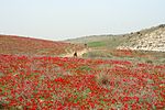
Karatiyya (Arabic: كرتيا) was a Palestinian Arab village of 1,370, located 29 kilometers (18 mi) northeast of Gaza, situated in a flat area with an elevation of 100 meters (330 ft) along the coastal plain of Palestine and crossed by Wadi al-Mufrid.
Excerpt from the Wikipedia article Karatiyya (License: CC BY-SA 3.0, Authors, Images).Karatiyya
35, Shafir Regional Council
Geographical coordinates (GPS) Address Nearby Places Show on map
Geographical coordinates (GPS)
| Latitude | Longitude |
|---|---|
| N 31.643611111111 ° | E 34.725833333333 ° |
Address
35
7935000 Shafir Regional Council
South District, Israel
Open on Google Maps


