place

Strawberry Peak

Los Angeles County, California geography stubsMountains of Los Angeles County, CaliforniaMountains of Southern CaliforniaSan Gabriel Mountains
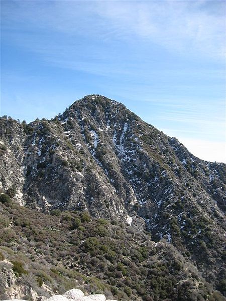
Strawberry Peak west face

Strawberry Peak (6,164 ft or 1,879 m) is a prominent peak in the San Gabriel Mountains of Los Angeles County, California. It is located about 10 miles (16 km) north of Pasadena, and 28 miles (45 km) from Los Angeles, along the Angeles Crest Highway. Strawberry Peak is the tallest of the front range peaks, being three feet higher than nearby San Gabriel Peak. Both can be widely seen from greater Los Angeles and the San Gabriel Valley, and are popular with hikers. Other prominent nearby peaks include Josephine Peak and Mount Wilson. Strawberry Peak was named by mountaineers over a century ago, who felt the peak resembled an enormous upside-down strawberry.The peak can be ascended on the east side as a 7.2-mile round-trip trail walk using Strawberry Peak Trail, which begins near the Red Box Picnic Area, or from the west as a class 3 scramble from a trailhead near the entrance to the Switzer Picnic Site.The area was closed to the public as a result of the Station Fire. However, the last closure order expired on May 24, 2014. Remaining fire damage in the area is minimal. It is especially common to see Rattlesnakes in the area.

Excerpt from the Wikipedia article Strawberry Peak (License: CC BY-SA 3.0, Authors, Images).

Strawberry Peak
Colby Canyon Trail,

Geographical coordinates (GPS) Address Nearby Places
placeShow on map

Wikipedia: Strawberry PeakContinue reading on Wikipedia

Geographical coordinates (GPS)

Latitude Longitude
N 34.2836126 ° E -118.1203487 °
placeShow on map

Address

Colby Canyon Trail

Colby Canyon Trail

California, United States
mapOpen on Google Maps

Strawberry Peak west face
Share experience

Nearby Places

Mount Lowe (California)

Mount Lowe is a mountain on the southern fold of the San Gabriel Mountains. Originally named Oak Mountain, it was renamed for Professor Thaddeus S.C. Lowe, who is credited for being the first person to set foot on and plant the American flag at its peak, and who built the Mount Lowe Railway to its foot in 1896. The record of the naming was made official by Andrew McNally, the famous Chicago map printer and summertime resident of Altadena, who promised to print "Mount Lowe" on all his maps. Mt. Lowe was established as an alternate route for the Mount Lowe Railway when attempts to procure rights of way to the more prominent Mount Wilson had failed. A number of trails stem from it due to the Mount Lowe Tavern which was built at Crystal Springs below the summit and operated from 1895 to 1936. One of the historic trails was the "Mount Lowe Eight" which was a mule ride attraction of the hotel that made a figure eight shaped route starting at the Tavern, ascending the summit of Mt. Lowe, returning to the Tavern, and crisscrossing to a trail that headed down Castle Canyon. From there the trail passed down to the Echo Mountain resort and ascended on the return to the Tavern. Mount Lowe was the upper terminus of the Alpine Division of the Mount Lowe Railway originally incorporated by Professor Lowe as the Pasadena and Mt. Wilson Railroad Co.Mt. Lowe is approachable from Echo Mountain or Chaney trail via a fire road which was graded over the old railway right-of-way.

Sam Merrill Trail
Sam Merrill Trail

The Sam Merrill Trail is a major hiking trail in the Las Flores Canyon of the San Gabriel Mountain Range north of Altadena, California, which leads to the top of Echo Mountain. It was built by Charles Warner and the Forest Conservation Club of Pasadena during the 1930s. After the deluge of 1938 most of the trails that accessed the mountain sides around Echo Mountain and the Mount Lowe Railway had been all but washed away. Sam Merrill found it important to maintain public hiking access to the railway ruins and other portions of the treacherous foothill. During the 1940s he overhauled and maintained the trail. As a young man Merrill had lived with John Muir for a summer, which inspired a lifetime commitment to the outdoors and the Sierra Club. Merrill, who served as Clerk of the Superior Court of Los Angeles, was an active volunteer in the Sierra Club, leading outings for almost twenty years, serving on the Executive Committee of the Angeles Chapter from 1926 to 1935 and on the National Board of Directors of the Sierra Club from 1936 to 1937. When Sam Merrill died in 1948 the Sierra Club named the Echo Mountain Trail after him. The trail originated at the old railway's right of way just above a point called Hygeia Station and climbed by switchback up the steep face of the Echo promontory. In the late 1960s a housing development was established over the trail, and the trailhead was moved to an access alongside the Cobb Estate gateway at the top of Lake Avenue. The portion of the trail which was maintained by Merrill leads an approximate 21⁄2-mile trip directly to Echo Mountain and the ruins of the White City of the Mount Lowe Railway. It is also sometimes referred to as Lower Sam Merrill Trail because a section of the Mount Lowe 8, an old mule trail from the days of the Mount Lowe Tavern, was reopened, giving a continued hike into Grand Canyon and the site of the Tavern, and is referred to as Upper Sam Merrill Trail. In 1996 the national USA Today newspaper published a list of "10 Great North American Hikes", which included the Sam Merrill Trail as one of them. The list had originally appeared in the October 1996 issue of Men's Fitness magazine.

Mount Lowe Railway
Mount Lowe Railway

The Mount Lowe Railway was the third in a series of scenic mountain railroads in the United States created as a tourist attraction on Echo Mountain and Mount Lowe, north of Los Angeles, California. The railway, originally incorporated by Thaddeus S. C. Lowe as the Pasadena and Mt. Wilson Railroad Co., existed from 1893 until its official abandonment in 1938, and was the only scenic mountain, electric traction (overhead electric trolley) railroad ever built in the United States. Lowe's partner and engineer was David J. Macpherson, a civil engineer graduate of Cornell University. The Mount Lowe Railway was a fulfillment of 19th century Pasadenans' desire to have a scenic mountain railroad to the crest of the San Gabriel Mountains. The Railway opened on July 4, 1893, and consisted of nearly seven miles (11 km) of track starting in Altadena, California, at a station called Mountain Junction. Atop Echo Mountain was a 70-room Victorian hotel, the Echo Mountain House. A short distance away stood the 40-room Echo Chalet, which was ready for opening day. Other buildings on Echo Mountain included an astronomical observatory, car barns, dormitories, repair facilities, a casino and dance hall, and a menagerie of local fauna.For the seven years during which Lowe owned and operated the railway, it was not financially successful, and was eventually sold. A series of natural disasters destroyed the facilities, the first of which was a kitchen fire that destroyed the Echo Mountain House in 1900. Further fires and floods eventually destroyed any remaining facilities, and the railway was officially abandoned in 1938 after a flood washed railway property off the mountain sides. The ruins of Mount Lowe Railway remain. It was placed on the National Register of Historic Places on January 6, 1993, a listing that was enlarged in January 2015.