place

Gran Canaria Airport

1930 establishments in SpainAirports established in 1930Airports in the Canary IslandsBuildings and structures in Gran CanariaPages with disabled graphs
Space Shuttle Emergency Landing SitesTransport in Gran Canaria
Airport LPA
Airport LPA

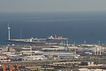
Gran Canaria Airport (IATA: LPA, ICAO: GCLP) (Spanish: Aeropuerto de Gran Canaria) is a passenger and freight airport on the island of Gran Canaria. It is an important airport within the Spanish air-transport network (owned and managed by a public enterprise, AENA), as it holds the sixth position in terms of passengers, and fifth in terms of operations and cargo transported. It also ranks first of the Canary Islands in all three categories, although the island of Tenerife has higher passenger numbers overall if statistics from the two airports located on the island are combined. The facility covers 553 hectares (1,370 acres) of land and contains two 3,100m runways.The airport is located in the eastern part of Gran Canaria on the Bay of Gando (Bahía de Gando), 19 km (12 mi) to the south of Las Palmas, and 25 km (16 mi) from the popular tourist areas in the south. In 2014 it handled over 10.3 million passengers, ranking 1st in the Canary Islands and 5th in Spain by passenger traffic. Gran Canaria Airport is an important hub for passengers travelling to West Africa (Morocco, Mauritania, Senegal, Cape Verde, among others), and to the Atlantic Isles of Madeira and the Azores. It serves as base for Binter Canarias, Canaryfly, Ryanair, Norwegian Air Shuttle and Vueling. Other airlines use it as a base to operate charter flights to Cape Verde and Gambia (TUI fly Deutschland and TUI fly Nordic), but only in the winter.

Excerpt from the Wikipedia article Gran Canaria Airport (License: CC BY-SA 3.0, Authors, Images).

Gran Canaria Airport
Calle Benavente,

Geographical coordinates (GPS) Address External links Nearby Places
placeShow on map

Wikipedia: Gran Canaria AirportContinue reading on Wikipedia

Geographical coordinates (GPS)

Latitude Longitude
N 27.931944444444 ° E -15.386666666667 °
placeShow on map

Address

Aeropuerto de Gran Canaria

Calle Benavente
35240 , Ojos de Garza
Spain
mapOpen on Google Maps

linkWikiData (Q1130612)
linkOpenStreetMap (16836930)

Airport LPA
Airport LPA
Share experience

Nearby Places

Gando Air Base
Gando Air Base

The Gando Air Base (in Spanish: Base Aérea de Gando) is a base of the Spanish Air and Space Force located in the Gran Canaria island, Spain, and next to the Gran Canaria Airport, eastward from its runways. Beyond several hangars opposite to the passenger terminal, the Gando Air Base contains ten shelters situated on the southern end of the eastern runway. They harbor the 46 Wing (Ala 46) which operates F/A-18 Hornet and CASA/IPTN CN-235 aircraft, and the SAR Eurocopter AS 532. The 46 Wing is composed of the 462 fighter (c. 22 F/A-18s) and 802 transport squadrons (3 CN-235 and 3 Cougar) and it defends the Spanish airspace around the Canary Islands. The 46th Wing is to convert from the F-18 Hornet to the Eurofighter Typhoon starting in 2026. The Gando Air Base is one of the biggest and most important air bases of the Spanish Air and Space Force and it is unique because of the wide variety of aircraft which it operates. Military activity was most intense during the mid-1970s, at the time of the crisis of decolonisation of Western Sahara and its occupation by Morocco. Military crises in Western Africa, like the 2013 Mali intervention by France, made Gando Air Base the main air platform for operations in Western Africa area by NATO. In 2006 Spain proposed Gando Air Base as headquarters for the newly created United States Africa Command (AFRICOM), but the AFRICOM HQ was ultimately based in Stuttgart, Germany. The Canary Islands Air Command (Mando Aéreo de Canarias – MACAN) is based in the city of Las Palmas. Canary Islands Air Command is the only territorial general Air Force Command in Spain; its mission is the maintenance, preparation and command of air units located in the Canary archipelago. Any Spanish military airplane that lands in the Canary Islands is immediately put at the disposal of the Canary Islands Air Command, who can retain it and use it as long as necessary for missions within the islands. This happens sometimes with heavy military transport, antisubmarine warfare and early warning airplanes, since the islands do not have these on a permanent basis. Once the plane is released by the Canary Islands Air Command, it can leave the Canary Islands and it reverts to the Air Force Commands of mainland Spain. The deployment base of Gando Air Base is the Lanzarote Military Airfield (Aeródromo Militar de Lanzarote). Lanzarote Military Airfield has its own permanent Air Force troops platoons and an air defence radar (the EVA 22, which covers the Eastern Canary Islands and the maritime area up to the Sahara), but it has no permanently based military planes, using the ones from Gando.

Vecindario
Vecindario

Vecindario is a town in the municipality of Santa Lucía de Tirajana in the south-eastern part of the island of Gran Canaria, in the Province of Las Palmas, in the Canary Islands. The population of Vecindario was estimated at 80 235 inhabitants in the 2023 census. Its current president is D. Francisco José García López. Vecindario is located in the coastal area of the municipality of Santa Lucia de Tirajana being the 3rd in population of the island and the 5th of the archipelago. Its population centres are El Doctoral, San Pedro Mártir, La Paredilla, La Cerruda, Hoya Pavón, San Rafael, El Canario, Casa Pastores, Cruce de Sardina, Sardina, La Vereda, Los Llanos and Balos. Vecindario has an estimated population of almost 80 235 inhabitants. It is located about 35 km from Las Palmas de Gran Canaria, the capital of the island, 15 km from the airport of Gran Canaria and another 15 km from Maspalomas, the main tourist area of the island. Vecindario is the nerve centre of the south-eastern conurbation of Gran Canaria, consisting mainly of the coastal neighbourhoods of the municipalities of Santa Lucía de Tirajana, Agüimes and Ingenio, which are all on the island of Gran Canaria. Other towns in this conurbation, which has around 120,000 inhabitants, are Cruce de Arinaga, Playa de Arinaga (Agüimes) and Carrizal (Ingenio). Agriculture was the main economic activity of Vecindario until the last quarter of the twentieth century for the production of tomatoes and other vegetables for export, when the service sector (especially trade) became predominant. At present, Vecindario is the largest urban open-air shopping centre on the island of Gran Canaria, together with the C.C. Atlántico and others of lesser importance such as C.C. Mercacentro, C.C. La Ciel and C.C. Avenida.