place

Pilning railway station
DfT Category F2 stationsFormer Great Western Railway stationsLow usage railway stations in the United KingdomPages with no open date in Infobox stationRailway stations in Bristol, Bath and South Gloucestershire
Railway stations in Great Britain opened in 1886Railway stations served by Great Western RailwaySouth Wales Main LineUse British English from May 2017
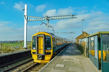
158954 at Pilning
158954 at Pilning

Pilning railway station is a minor station on the South Wales Main Line near Pilning, South Gloucestershire, England. It is 10 miles (16 km) from Bristol Temple Meads and is the last station on the English side before the Severn Tunnel through to Wales. Its three letter station code is PIL. It is managed by Great Western Railway, who provide the two train services per week from the station. The station was opened by the Bristol and South Wales Union Railway in 1863, but was resited in 1886 when the Severn Tunnel was opened. The station had an extensive goods yard, boasting one of the largest railway communities in the Bristol area, and operated a motorail service to Wales. In 1928 the original station was reopened on the Severn Beach Line, which allowed passengers and freight to reach Avonmouth Docks, though this only lasted until 1964. The goods yard was closed in 1965, and the station buildings later demolished, with very little in the way of facilities. Passenger services also declined, to two trains per day in the 1970s and the current service level of two trains per week in 2006. The station's footbridge was removed in 2016 as part of Great Western Main Line electrification project, meaning that only eastbound trains can now use the station. Campaigners have alleged this is part of an attempted closure by stealth, although the incident raised the station's profile nationally. Pilning is one of the least-used stations in Britain, but passenger numbers have increased in recent years due to efforts by the Pilning Station Group.

Excerpt from the Wikipedia article Pilning railway station (License: CC BY-SA 3.0, Authors, Images).

Pilning railway station
Station Road,

Geographical coordinates (GPS) Address Nearby Places
placeShow on map

Wikipedia: Pilning railway stationContinue reading on Wikipedia

Geographical coordinates (GPS)

Latitude Longitude
N 51.5563 ° E -2.6265 °
placeShow on map

Address

Station Road
BS35 4JH , Pilning and Severn Beach
England, United Kingdom
mapOpen on Google Maps

158954 at Pilning
158954 at Pilning
Share experience

Nearby Places

Easter Compton
Easter Compton

Easter Compton is a village in the civil parish of Almondsbury, South Gloucestershire, England. It is situated at the bottom of a hill (known as Blackhorse Hill) near Junction 17 of the M5 Motorway on the B4055 road. The village is only 1.5 miles away from 'The Mall' shopping centre and leisure complex at Cribbs Causeway. There is a pub (The Fox), a post office (open Monday/Wednesday/Friday in the mornings and based in the village hall), Methodist chapel, bowling alley, and a playing field (including skate park). It is served by the church of Compton Greenfield, as well as the chapel in the village. The B4055 road leads to Pilning, Redwick and Severn Beach. The National Cycle Network runs through the village on its way to the Severn Bridge by which it is possible to enter Wales on foot or bicycle. There are some walks locally which give great views of the surrounding countryside, especially from the top of Spaniorum Hill. Each year in June, the village holds a carnival. The main road through the village is closed and the carnival procession finishes on the playing field where the floats are judged and various entertainments and stalls are available. In 2006, due to insurance restrictions, the carnival, previously drawn by lorries and vans provided by a local haulage firm, was restricted to non-motorised transport and the traditional throwing of water and flour was forbidden. In recent times the carnival has been cancelled due to the pandemic. The village also puts on a large fireworks display on 5 November to mark Guy Fawkes Night. Bristol Zoo is planning to open a large zoological and adventure park in woodland which it owns adjacent to Blackhorse Hill.The Wave Bristol, a park with a 200 metre long artificial wave pool for surfing opened near the village in 2019.

Over, South Gloucestershire

Over is a village in the civil parish of Almondsbury in South Gloucestershire, England, 6 miles (10 km) north of Bristol. It lies on the B4055, a road that parallels the M5 from Junction 17 to 16. The road, known locally as Over Lane, abuts to the east a ridge which overlooks the Severn floodplain, dominated by Bristol Golf Club or Course. According to local legends, a ghost of an old woman haunts this place every New Year's Eve.Over Court had a large deer park, which was largely replaced in the 20th century by the golf venue.A similar deer park was higher and to the north at Knole Park, the house of which was centred on a small knoll which was a fortified Roman camp. Most of its grounds have been replaced by a large brick quarry, Springwood Nurseries and Almondsbury's paired garden centres which are notable for large outdoor areas. Beyond the clustered settlement, before the lane climbs to the north it passes over the London to South Wales Main Line, a railway emerging from Patchway Tunnel before heading across the Severn floodplain to the Severn Tunnel. Its main station is Bristol Parkway station a few miles to the southeast. Via mainly rural, linear Easter Compton parish or footpaths and tiny lanes which follow the line closely Pilning railway station is a walk about 2 miles (3.2 km) away. The area is road-dominated and the loss of the deer parks has led to little tourism. In 2015 Pilning it was the sixth least used station in the UK — 68 passenger entries/exits were recorded for the year.