place

Matinkylä

Districts of EspooPages with Finland Swedish IPAPages with Finnish IPASouthern Finland Province geography stubs
Espoo districts Matinkyla

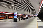
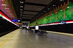
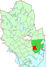
Matinkylä (Finnish: [ˈmat̪inˌkylæ]; Swedish: Mattby, Finland Swedish: [ˈmatˌby]; both literally translated the "village of Matt/Matti") is one of the major districts of Espoo, a city on the southern coast of Finland. Matinkylä sits between the Länsiväylä highway and the coast of the Gulf of Finland, between the areas of Haukilahti and Iivisniemi.The middle part of Matinkylä consists of high apartment buildings, whereas the southern part consists of terraced houses and shorter apartment buildings. There are also some detached houses and paired houses in the area. Iirislahti in eastern Matinkylä, as well as Nuottalahti, Nuottaniemi and Koukkuniemi in southern Matinkylä consist of smaller houses. Matinkylä also has a marine area with many islands, such as Iso Vasikkasaari and Miessaari. About 30,000 people live in the Greater Matinkylä area, consisting of Matinkylä itself and the neighbouring areas of Olari and Henttaa. Iso Omena, one of Finland's biggest shopping malls, is situated in Matinkylä. Matinkylä was the final stop of the Länsimetro, until the extension to Kivenlahti was finished on December 2022.

Excerpt from the Wikipedia article Matinkylä (License: CC BY-SA 3.0, Authors, Images).

Matinkylä
Gräsantörmä, Espoo Olari (Suur-Matinkylä)

Geographical coordinates (GPS) Address Nearby Places
placeShow on map

Wikipedia: MatinkyläContinue reading on Wikipedia

Geographical coordinates (GPS)

Latitude Longitude
N 60.166666666667 ° E 24.75 °
placeShow on map

Address

Gräsantörmä
02230 Espoo, Olari (Suur-Matinkylä)
Finland
mapOpen on Google Maps

Espoo districts Matinkyla
Share experience

Nearby Places

Niittykumpu
Niittykumpu

Niittykumpu (Finnish) or Ängskulla (Swedish) is a district of Espoo, a city in Finland. The districts belongs to the major district of Suur-Tapiola. The district, partly located on the eastern lands of the former Gräsa manor, started developing along with the rest of southern Espoo in the 1930s when the street Jorvaksentie (now known as the Länsiväylä highway) was completed. The first significant construction phase of Niittykumpu happened during the 1960s and 1970s, when a large number of terraced houses were built in the area because of rapid growth of the city of Espoo. Construction slowed down during the early 1990s depression in Finland. Construction picked up pace again in the 2000s and increased even further during the construction of the Länsimetro transport line. The oldest lower stage primary school, the Niittykumpu school, is located in Niittykumpu. The automobile dealership concentration around the street Merituulentie has been called "the automobile street of Espoo", even though some of the dealerships have slowly moved away from Niittykumpu because of further construction of Länsimetro. At the turn from 2021 to 2022 Niittykumpu had a population of 7,085 and a population density of 3,374 people per square kilometre. Niittykumpu is served by the Länsimetro line belonging to the trunk routes of the Helsinki Regional Transport Authority, and the Niittykumpu metro station is located in connection with the metro centre located in southern part of the district and the shopping centre Niitty.