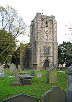
Worsthorne-with-Hurstwood
Civil parishes in LancashireGeography of Burnley

Worsthorne-with-Hurstwood is a civil parish in the Borough of Burnley, in Lancashire, England. Situated on the eastern outskirts of Burnley, in 2011 it had a population of 2,963.The parish contains part of the Pike Hill and Brownside suburbs of Burnley, the village of Worsthorne and the hamlet of Hurstwood and the rural area east of the town. The parish adjoins the Borough of Burnley parishes of Briercliffe and Cliviger, the unparished area of Burnley and the West Yorkshire district of Calderdale.
Excerpt from the Wikipedia article Worsthorne-with-Hurstwood (License: CC BY-SA 3.0, Authors, Images).Worsthorne-with-Hurstwood
Geographical coordinates (GPS) Address Nearby Places Show on map
Geographical coordinates (GPS)
| Latitude | Longitude |
|---|---|
| N 53.78 ° | E -2.18 ° |
Address
BB10 3LQ , Worsthorne-with-Hurstwood
England, United Kingdom
Open on Google Maps


