Choctawhatchee River
Alabama placenames of Native American originBodies of water of Barbour County, AlabamaBodies of water of Bay County, FloridaBodies of water of Dale County, AlabamaBodies of water of Geneva County, Alabama ... and 8 more
Bodies of water of Henry County, AlabamaBodies of water of Holmes County, FloridaBodies of water of Okaloosa County, FloridaBodies of water of Walton County, FloridaFlorida placenames of Native American originOutstanding Florida WatersRivers of AlabamaRivers of Florida

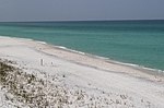
The Choctawhatchee River is a 141-mile-long (227 km) river in the southern United States, flowing through southeast Alabama and the Panhandle of Florida before emptying into Choctawhatchee Bay in Okaloosa and Walton counties. The river, the bay and their adjacent watersheds collectively drain 5,350 square miles (13,900 km2).
Excerpt from the Wikipedia article Choctawhatchee River (License: CC BY-SA 3.0, Authors, Images).Choctawhatchee River
Geographical coordinates (GPS) Address Nearby Places Show on map
 Continue reading on Wikipedia
 Geographical coordinates (GPS)
| Latitude | Longitude |
|---|---|
| N 30.4038 ° | E -86.12355 ° |
Address
Walton County (Walton)
Florida, United States
Open on Google Maps