place

Bushey railway station

1841 establishments in EnglandDfT Category E stationsFormer London and North Western Railway stationsLondon stations without latest usage statistics 1415London stations without latest usage statistics 1516
London stations without latest usage statistics 1617Proposed London Underground stationsRail transport stations in London fare zone 8Railway stations in Great Britain opened in 1841Railway stations in WatfordRailway stations served by London OvergroundRailway stations served by West Midlands TrainsStations on the West Coast Main LineUse British English from August 2012
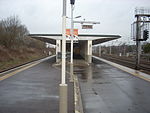
Bushey station Overground platforms looking north

Bushey is a railway station in Hertfordshire which serves Bushey and Oxhey. It is situated on the West Coast Main Line, 5 miles (8 km) north of Harrow & Wealdstone, on an embankment. North of the station, the railway crosses the Colne valley on several viaducts. The station is served by London Northwestern Railway semi-fast trains on the West Coast main line, and by London Overground services on the Watford DC line, a slow local service along the West Coast route. At Bushey, this branches west on a loop to serve Watford High Street railway station, before rejoining the main line at Watford Junction.

Excerpt from the Wikipedia article Bushey railway station (License: CC BY-SA 3.0, Authors, Images).

Bushey railway station
Bushey and Oxhey Railway Yard,

Geographical coordinates (GPS) Address Nearby Places
placeShow on map

Wikipedia: Bushey railway stationContinue reading on Wikipedia

Geographical coordinates (GPS)

Latitude Longitude
N 51.644 ° E -0.385 °
placeShow on map

Address

Bushey and Oxhey Railway Yard

Bushey and Oxhey Railway Yard
WD19 4EA , Watford Heath
England, United Kingdom
mapOpen on Google Maps

Bushey station Overground platforms looking north
Share experience

Nearby Places

Oxhey

Oxhey is a suburb of Watford, under the jurisdiction of the Watford Borough Council of the county of Hertfordshire, England. It is located at grid reference TQ125955 and is part of the Watford. It is in the Oxhey Ward of Watford Borough Council. Oxhey grew during the mid-19th century with the coming of the London and Birmingham Railway from London Euston to Boxmoor in 1837, the settlement being developed to house railway workers. The line was completed to Birmingham in 1838. It was originally called 'New Bushey', after the well-established village a mile away, but was renamed 'Oxhey' in 1907. Oxhey's parish church is St Matthew's, a Grade II listed building dating from 1880 in Gothic Revival style with some elements of early Art Nouveau decoration. The church also features a Karl Parsons window in the Lady Chapel.Oxhey Grange in Oxhey Lane was built in 1876 by architect William Young (1843-1900) in the High Victorian Gothic style. It is a Grade II listed building. The wider locations which comprise the modern Oxhey area are Oxhey Village (the area around Bushey station and between Pinner Road and London Road), Oxhey Hall (the area along Hampermill Lane towards Moor Park) and South Oxhey, although this is really a suburb in itself which is adjacent to Oxhey. It is an oddity that the main line station, which serves both Oxhey and the town of Bushey a mile away, is situated on the edge of Oxhey Village and yet is called Bushey Station. The original name of the station was 'Bushey', it was renamed 'Bushey & Oxhey' when Oxhey Village was renamed, and was then renamed again in 1974.

Watford
Watford

Watford ( (listen)) is a town and borough in Hertfordshire, England, 15 miles northwest of Central London, on the River Colne. Initially a small market town, the Grand Junction Canal encouraged the construction of paper-making mills, print works, and breweries. While industry has declined in Watford, its location near London and transport links has attracted several companies to site their headquarters in the town. Cassiobury Park is a public park that was once the manor estate of the Earls of Essex. The town developed next to the River Colne on land belonging to St Albans Abbey. In the 12th century, a charter was granted allowing a market, and the building of St Mary's Church began. The town grew partly due to travellers going to Berkhamsted Castle and the royal palace at Kings Langley. A mansion was built at Cassiobury in the 16th century. This was partly rebuilt in the 17th century and another country house was built at The Grove. The Grand Junction Canal in 1798 and the London and Birmingham Railway in 1837 resulted in Watford's rapid growth, with paper-making mills such as John Dickinson at Croxley, influencing the development of printing in the town. Two brewers, Benskins and Sedgwicks, amalgamated and flourished in the town until their closure in the late 20th century. Hertfordshire County Council designates Watford to be a major sub-regional centre. Several head offices are based in Watford. International conferences and sporting events have also taken place in Watford, including the 2006 World Golf Championship, the 2013 Bilderberg Conference and the 2019 NATO summit which all took place at The Grove.Watford became an urban district under the Local Government Act 1894 and a municipal borough by grant of a charter in 1922. The borough, which had 90,301 inhabitants at the 2011 census, is separated from Greater London to the south by Three Rivers District. Watford Borough Council is the local authority with the Mayor of Watford as its head – one of only 18 directly elected mayors in England and Wales.