place

J. Y. Dykman Store

Buildings and structures in Putnam County, New YorkCommercial buildings on the National Register of Historic Places in New York (state)National Register of Historic Places in Putnam County, New York
JY Dykman Store
JY Dykman Store

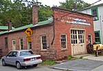
The J.Y. Dykman Store is located at Main (NY 301) and Pearl streets in the village of Nelsonville, New York, United States, across from the Fish and Fur Club, now the village hall. Like that building, it was listed on the National Register of Historic Places in 1982. It is currently an antique map store. It is a one-story, four-bay clapboard-sided frame building. Three of the front four bays are taken up by wood-framed plate glass windows and the recessed double-door entrance with single-light transom; the western bay is a garage added later on. Above it is a bracketed sheet metal entablature with the words "J.Y. DYKMAN" and fleur-de-lis and swag motifs on the fascia and pilaster capitals.The 1876 Beers map of the Nelsonville area, the earliest one, shows the corner as part of the Gouverneur estate. By 1912 James Y. Dykman, a prominent local businessman who had already opened a feed store nearby, is listed as the owner of a grocery at the site. By the late 20th century it had become Hudson Rogue, a dealer in antique maps and prints.

Excerpt from the Wikipedia article J. Y. Dykman Store (License: CC BY-SA 3.0, Authors, Images).

J. Y. Dykman Store
Pearl Street,

Geographical coordinates (GPS) Address Nearby Places
placeShow on map

Wikipedia: J. Y. Dykman StoreContinue reading on Wikipedia

Geographical coordinates (GPS)

Latitude Longitude
N 41.423333333333 ° E -73.948888888889 °
placeShow on map

Address

Pearl Street 63
10516
New York, United States
mapOpen on Google Maps

JY Dykman Store
JY Dykman Store
Share experience

Nearby Places

Cold Spring Historic District

The Cold Spring Historic District is a historic district that includes much of the central area of the Hudson River Cold Spring village in Putnam County, New York. It is roughly bounded by Main Street (in the northeastern portion of the village the eastern end of NY 301), Cedar and Fair streets and Paulding Avenue. It gives Cold Spring its quaint character and has been described as "one of the best-preserved 19th century townscapes in the Hudson River region". A consultants' report for the village's 1987 master plan quotes the National Register of Historic Places saying, upon adding the district in 1982: As a surviving industrial village, Cold Spring's commercial, ecclesiastical and residential features reflect the economic and social dynamics of the (early 19th century) era. The distinctive store structures on the broad Main Street, the noticeable contrast of house types and neighborhoods and the variety of religious institutions dominated by the foundry owner's donated Episcopal church, are the legacy of the prosperous and paternalistic society in nineteenth century Cold Spring. They are significant today for their architectural and historical associations to important events in the history of the Hudson Highlands Most of the houses, churches and other buildings came into existence in the years before the Civil War, when the nearby West Point Foundry was at the peak of its production and workers were rapidly moving into the area. Today the district includes over 200 buildings, many of them contributing properties. They have helped transform the village into a popular upscale residence for commuters and weekend destination for New York City residents due to the nearby Metro-North train station offering easy access to Grand Central Terminal.