North Park, San Diego

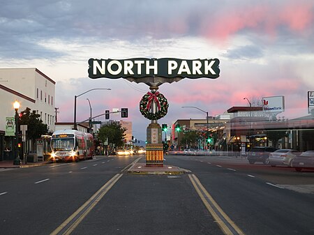
North Park is a neighborhood in San Diego, California, United States, as well as a larger "community" as defined by the City of San Diego for planning purposes. The neighborhood is bounded: on the northwest by Park Boulevard and University Heights on the west by Florida Canyon and both University Heights and Hillcrest on the southwest by Balboa Park on the south by Switzer Canyon and the South Park neighborhood on the east by Interstate 805 and City HeightsThe pre-Interstate 805 boundary of North Park was widely considered to be 35th Street, which is now part of City Heights. It includes the sub-neighborhoods of Burlingame, Altadena, and the Morley Field area (site of the Dryden Historic District). North Park is part of the 53rd congressional district, and San Diego City Council District 3. The "community" of North Park as defined for planning purposes includes University Heights on the north and Juniper Canyon as the southern boundary, thus including as far southeast as Cedar Ridge Park in the officially defined community.The North Park sign can be seen at 30th Street and University Avenue, and this intersection is considered to be the heart of the neighborhood.
Excerpt from the Wikipedia article North Park, San Diego (License: CC BY-SA 3.0, Authors, Images).North Park, San Diego
Upas Street, San Diego North Park
Geographical coordinates (GPS) Address Phone number Website Nearby Places Show on map
Geographical coordinates (GPS)
| Latitude | Longitude |
|---|---|
| N 32.740830555556 ° | E -117.12971944444 ° |
Address
Cardomon Café
Upas Street 2977
92104 San Diego, North Park
California, United States
Open on Google Maps


