place

Mount Hood Avenue station

2001 establishments in OregonMAX Light Rail stationsMAX Red LineOregon building and structure stubsOregon transportation stubs
Railway stations in Portland, OregonRailway stations in the United States opened in 2001Tram stubsWestern United States railway station stubs
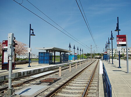
Mt Hood Avenue MAX station looking west Portland, Oregon

Mount Hood Avenue station is a light rail station on the MAX Red Line in Portland, Oregon. Located at the northern end of the Cascade Station development, it is the 2nd stop north on the Airport MAX. The street for which it is named, Mount Hood Avenue, is located about 1,200 feet (370 m) southeast of the station. Mount Hood is approximately 40 miles (64.3 km) away from the station.

Excerpt from the Wikipedia article Mount Hood Avenue station (License: CC BY-SA 3.0, Authors, Images).

Mount Hood Avenue station
Northeast Cascades Parkway, Portland

Geographical coordinates (GPS) Address Nearby Places
placeShow on map

Wikipedia: Mount Hood Avenue stationContinue reading on Wikipedia

Geographical coordinates (GPS)

Latitude Longitude
N 45.5771 ° E -122.567147 °
placeShow on map

Address

Mount Hood Avenue

Northeast Cascades Parkway
97200 Portland
Oregon, United States
mapOpen on Google Maps

Mt Hood Avenue MAX station looking west Portland, Oregon
Share experience

Nearby Places

Glenn L. Jackson Memorial Bridge

The Glenn L. Jackson Memorial Bridge, or I-205 Bridge, is a segmental bridge that spans the Columbia River between Portland, Oregon and Vancouver, Washington. It carries Interstate 205, a freeway bypass of Portland, Oregon. The structure is maintained by the Oregon Department of Transportation. Planning for the structure began in earnest in 1964 when it was designated as part of the East Portland Freeway (later renamed Veteran's Memorial Freeway), Interstate 205. Construction began in August 1977. In order to avoid disrupting river traffic, the bridge was built one segment at a time. The segments, weighing upwards of 200 tons, were cast 4 miles (6.4 km) downstream and barged into place. The bridge was opened on December 15, 1982. The finished project cost was $169.6 million: $155.7 million from Federal funds, $4 million from Washington state funds and $9.9 million from Oregon state funds. Three men died during its construction. The bridge was closed to traffic on May 15, 1983, for a one-day festival named "People's Day", where 125,000 pedestrians crossed the bridge.It is a twin structure with four lanes in each direction and a 9-foot-wide (2.7 m) bicycle and pedestrian path in between. The bridge is 7,460 ft (2,270 m) long from the Washington side of the river to Government Island and another 3,120 ft (951 m) in length from Government Island to the Oregon side of the river. The main span, near the Washington side, is 600 ft (183 m) long with 144 ft (44 m) of vertical clearance at low river levels. The bridge was named for Glenn Jackson, the chairman of the Oregon State Highway Commission and later the Oregon Economic Development Commission.The average weekday traffic during 2019 was 166,152 vehicles. In 2020, ODOT and WSDOT began a one-year pilot project to allow C-Tran buses to use the shoulders of I-205 over the bridge in order to bypass congestion.No vehicle, bicycle or pedestrian access to Government Island is available from the bridge.