place

Hill School (South Dartmouth, Massachusetts)

Bristol County, Massachusetts Registered Historic Place stubsDartmouth, MassachusettsHistoric district contributing properties in MassachusettsNRHP infobox with nocatNational Register of Historic Places in Bristol County, Massachusetts
School buildings on the National Register of Historic Places in MassachusettsUse mdy dates from August 2023
DartmouthMA HillSchool

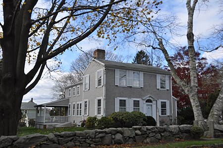
The Hill School is a historic school building (now a private residence) at 4 Middle Street in the Padanaram village of Dartmouth, Massachusetts. The two-story wood-frame structure was built c. 1806, and was established by the area's early settlers as a cooperative venture. It has a "3/4" facade, with three asymmetrically placed windows on each floor, and an off-center entry between two of them, with no window above. The building was moved about 450 feet (140 m) in 1912 to its present location.The building was listed on the National Register of Historic Places in 1980.

Excerpt from the Wikipedia article Hill School (South Dartmouth, Massachusetts) (License: CC BY-SA 3.0, Authors, Images).

Hill School (South Dartmouth, Massachusetts)
School Street,

Geographical coordinates (GPS) Address Nearby Places
placeShow on map

Wikipedia: Hill School (South Dartmouth, Massachusetts)Continue reading on Wikipedia

Geographical coordinates (GPS)

Latitude Longitude
N 41.586944444444 ° E -70.940277777778 °
placeShow on map

Address

School Street 24
02748
Massachusetts, United States
mapOpen on Google Maps

DartmouthMA HillSchool
Share experience

Nearby Places

Rural Cemetery and Friends Cemetery

The Rural Cemetery and Friends Cemetery are a pair of connected cemeteries at 149 Dartmouth Street in New Bedford, Massachusetts United States. They occupy an irregular parcel of land more than 90 acres (36 ha) in size on the west side of the city. Established in 1837, the Rural Cemetery was the fifth rural cemetery in the nation, after Mount Auburn Cemetery (Cambridge, Massachusetts), Mount Hope Cemetery (Bangor, Maine), Mount Pleasant Cemetery (Taunton, Massachusetts), and Laurel Hill Cemetery (Philadelphia, Pennsylvania). In its early days it was criticized as lacking some of the natural beauty afforded by rolling terrain; the early sections were laid out in rectilinear manner on relatively flat terrain. The cemetery was a popular burial site, including notably the landscape artist Albert Bierstadt and Governor of Massachusetts John H. Clifford.In contrast to the more decorative nature of the Rural Cemetery, the Friends Cemetery is much plainer. It consists of a roughly 2-acre (0.81 ha) parcel on one side of the Rural Cemetery, which was sold to the Dartmouth Friends in 1849, but is administered by the city. This section has less ornate markers, generally laid out in rectilinear fashion. It includes burials that were relocated from a Friends cemetery (dating to 1793) that had been located on the New Bedford waterfront.The cemeteries were listed on the National Register of Historic Places in 2014.

Acushnet Fort

Acushnet Fort was a fort that existed from 1776 to around 1820 on Eldridge Point in New Bedford, Massachusetts. It was originally built with Commonwealth resources during the American Revolution in 1776 with ten guns. Rebuilt in 1808 under the federal second system of fortifications, it could accommodate 40 men and had six guns and a magazine.The fort's exact location, especially in the Revolution, is uncertain. The fort appears in the Secretary of War's reports for 1808 and 1811; thus it was a federal fort at that time. In 1808 the entry is: "At the entrance of the inner harbor of New Bedford, two miles below the town, a small enclosed work has been erected of stone, brick, and sod. It commands the entrance into the harbor for a mile and a half in a direct line...". In 1811 the entry is: "At Eldridge Point, which commands the entrance of the harbor; an enclosed work of masonry, mounting six heavy guns...". The "two miles below the town" implies the fort was at or near Clark's Point, later the site of Fort Rodman. Another possibility is the area of Fairhaven known as Poverty Point or Oxford Point, part of which was once owned by the Eldredge family, although this is north of the harbor entrance. Fairhaven was part of New Bedford until 1812.A list of fort commanders shows that the Eldridge Point fort was commanded by Captain James Thomas of the Dragoons in 1810–1811, followed by 1st Lt. Henry Whiting, also of the Dragoons, in 1811–1812.By the time Fort Rodman was built in the 1850s, the fort no longer existed.